


NaviEdit Pro
- Supplier:
- EIVA
- Product no :
- NS.NEPRO
- Underwater inspections and surveys
- Cable, pipe and asset inspections
- UXO surveys
- Hydrography and geophysics
- USV- and vessel-based hydrographic inspections
- Harbour inspections
- Geophysical surveys
- Maritime constructions
- Dredging
- Cable lay
- Tow, mooring and riser handling
- Ocean science and archeology
- Environmental studies
- Archeology
Key features and benefits

Get the most out of your survey data...
... by having NaviEdit fix all the errors and problems in the data.
Get the most out of your survey data...
... by having NaviEdit fix all the errors and problems in the data
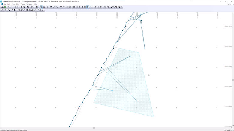
NaviEdit ensures that you get the most out of your survey data by fixing all the errors and problems in the data – regardless if these have arisen during the survey because of sensor errors, human errors or environmental impact.
Examples of what NaviEdit can be used for
- Changing mounting angles/offsets/C-O
- Switching between sensors, in case of (periodic) sensor dropout
- Smoothing or de-spiking of faulty/noisy sensors
- Correction for tide, including GPS tide calculations
- Sound velocity profile corrections – applying nearest SVP measurement or even synthesising an SVP if you do not have one
- Removing swell
- Calculation of pressure to depth, including utilising CTD profile and UNESCO formula
- USBL recalculation and weighting
- Changing geodetics
- Recalculating final result from GPS antenna to seabed
Moreover, NaviEdit keeps all raw data with angle/distance values. Consequently, you always have access to these and thus the possibility of editing them, fixing any problems seen further along in the editing workflow
It also means that changes often are instantaneous. For example, changing a mounting angle does not require data to be recalculated. When importing data to software for data visualisation such as NaviModel, this will connect directly to NaviEdit. If NaviModel is used, changes made in NaviEdit are reflected in the data being displayed and processed in the visualisation software.
-
Sensor processing
NaviEdit can be used to recalculate data very quickly and where our sensor processing takes place. Here we change offsets, C-O’s, mounting angles, apply tide, apply SVP, de-spike sensors, improve object positioning, Kalman filtering, remove swell etc.
Sensor processing features
NaviEdit can recalculate data very quickly and where sensor processing takes place. Here we change offsets, C-O’s, mounting angles, apply tide, apply SVP, de-spike sensors, improve object positioning, Kalman filtering, remove swell etc.
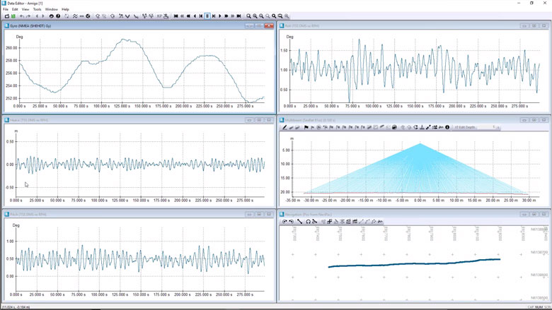
Surface positioning and motion (GPS, Gyro, IMU)
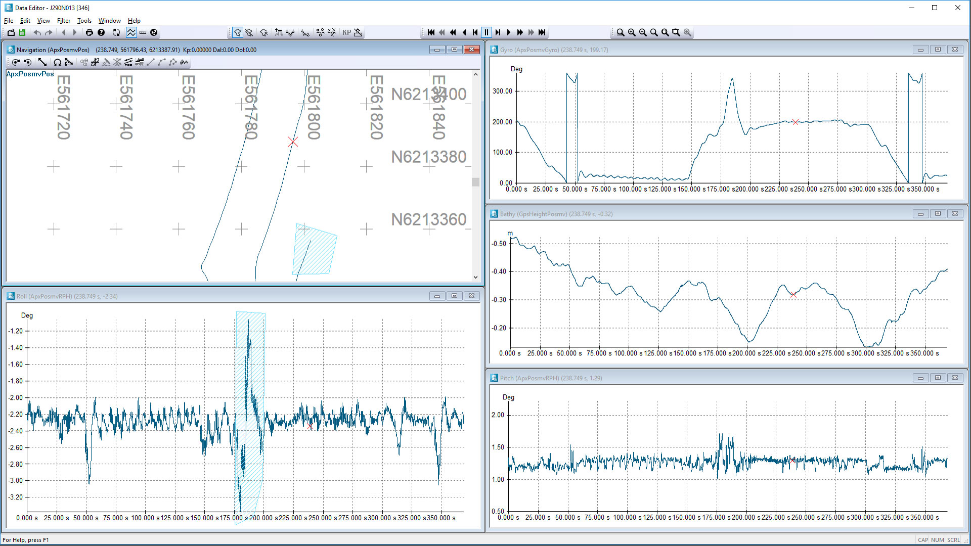
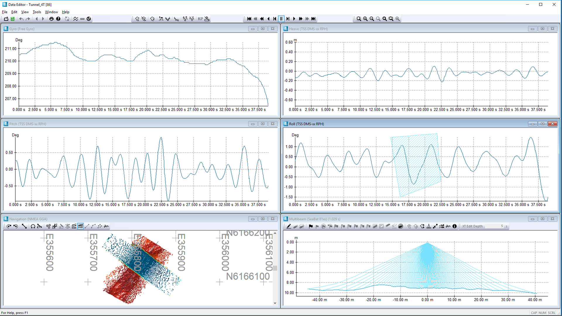
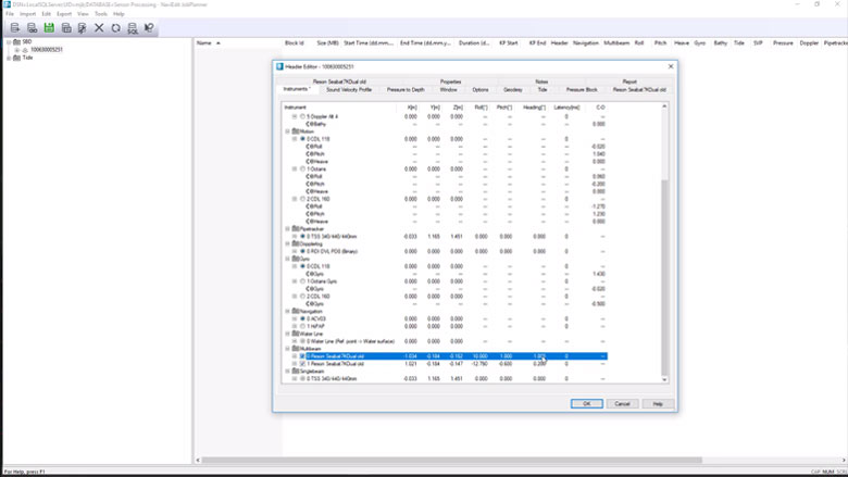
NaviEdit Header Editor allows the user to check the vessel setup.
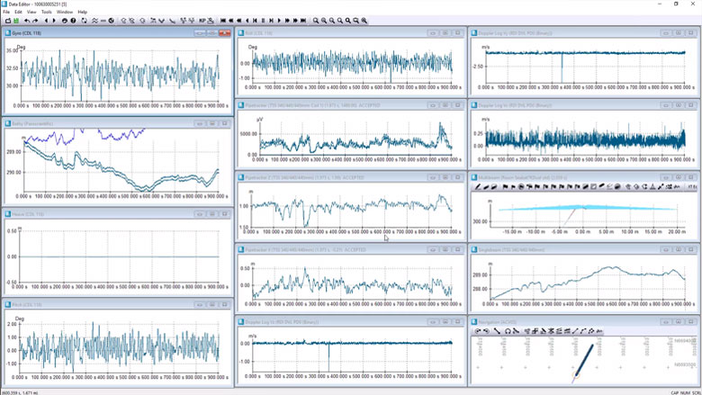
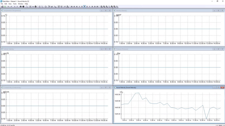
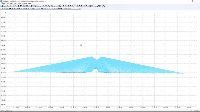
NaviEdit Data Editor allows the user to view and QC sensor data via a series of graphical displays.
Subsurface positioning (USBL, DVL, INS, Gyro, IMU)
You can check an ROV setup. View and QC sensor data via a series of graphical displays.
Tide corrections
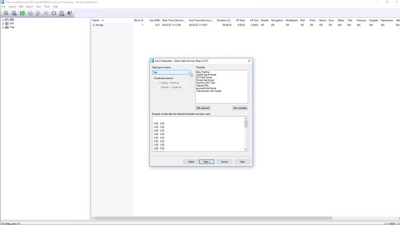
Predicted or observed tides can be imported into NaviSuite using user-defined import templates.
SVP corrections
CTD or SVP can be imported into NaviSuite using user-defined import templates.
Change offsets, C-O's and mounting angles
Sometimes incorrect measured offsets, C-O’s or mounting angles are entered into the online acquisition system. NaviSuite enables you to correct these errors.
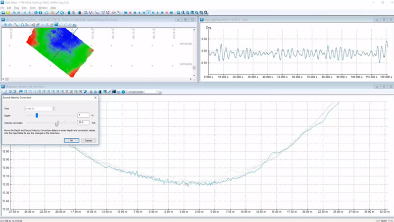
Raybending corrections
Sometimes Sound Velocity values are incorrect and we need a tool to perform a local correction. In NaviSuite, we can visualise the Sound Velocity corrections before we apply them.
Sensor editing (import and manual editing)
If required, you can run the following actions:• De-spike• Interpolate• Delete• Translate• Scale• Rotate• Smooth
-
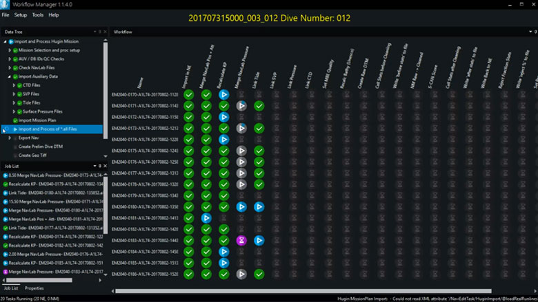
Workflow Manager – Desktop
The NaviSuite Workflow Manager software tool is designed to enable a previously unseen degree of automatic data processing.
Workflow Manager – Desktop
Let software do the hard data processing work
The Workflow Manager is a configurable workflow process automation tool. In other words, it allows you to automate the small steps you normally go through when processing subsea data.
The software is designed to enable a previously unseen degree of automatic data processing of massive amounts of subsea sensor data.
The Workflow Manager is a configurable workflow process automation tool
The Workflow Manager software comes in two variants:
- Workflow Manager – Desktop, which is described here
- Workflow Manager – Server
Workflow Manager – Desktop will be available for free when purchasing NaviEdit Pro and NaviModel Producer licences (the NaviSuite products dedicated to navigation/positioning and data modelling/visualisation respectively) during the beginning of 2019. It is currently in operation with and being tested by selected customers before official release. If you would like to learn more about the tool, please feel free to reach out to us.
This variant is limited to being able to run one NaviEdit and one NaviModel task in parallel, whereas Workflow Manager – Server can run an unlimited number of NaviEdit and NaviModel workflow steps in parallel (typically 30-100), resulting in a significant parallelisation of processing for large data sets, and significant savings in terms of man-hours spent on data processing.
Key benefits
- Faster data processing throughout your project through fewer manual tasks
- Better utilisation of your data processing staff’s time and competences
The optimal choice for hydrographic surveys carried out with a single boat
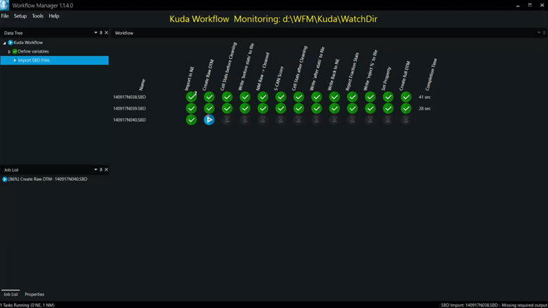
Workflow Manager – Desktop is especially relevant for use during shallow water surveys (in combination with NaviSuite Kuda software), where sonar and terrestrial LiDAR data is processed as you sail.
The Workflow Manager will automatically process each sonar and laser file as it is recorded, thus completing most of the processing during acquisition, leaving quality control as the only task for the data processer to carry out onshore. For those customers streaming data to the shore, the Workflow Manager can run either onboard before streaming, or onshore receiving streamed data.
Increasing amount of data processed in less time
Workflow Manager – Desktop can be applied to functions in NaviEdit Pro and NaviModel Producer (special versions of NaviEdit and NaviModel that run without a user interface are made available together with the Workflow Manager). The tool is also able to activate third-party scripts and tools.
The Workflow Manager tool will improve your data processing efficiency as:
- Repetitive tasks are automated
- Data processing staff can focus on errors, interpretations and quality control
- Many features normally carried out in NaviEdit and NaviModel are not only automated but have also been performance optimised for use with the Workflow Manager
The result is a powerful cocktail of high-speed data processing features.
How it works
You define the sequence of processing steps. With the setups we have seen so far, the task of defining your workflow is minimal – although it often gives you food for thought as to how you can optimise the way you work.
There are many types of steps available. A few examples are:
- Loading files, including waiting for files to become available
- Applying tide, SVP, etc
- Cleaning data in NaviModel
- Checking a number of quality control parameters such as density, gaps, noise levels, TVU, etc
- Correcting seabed height level across multiple surveys, etc
- Exporting data in different formats
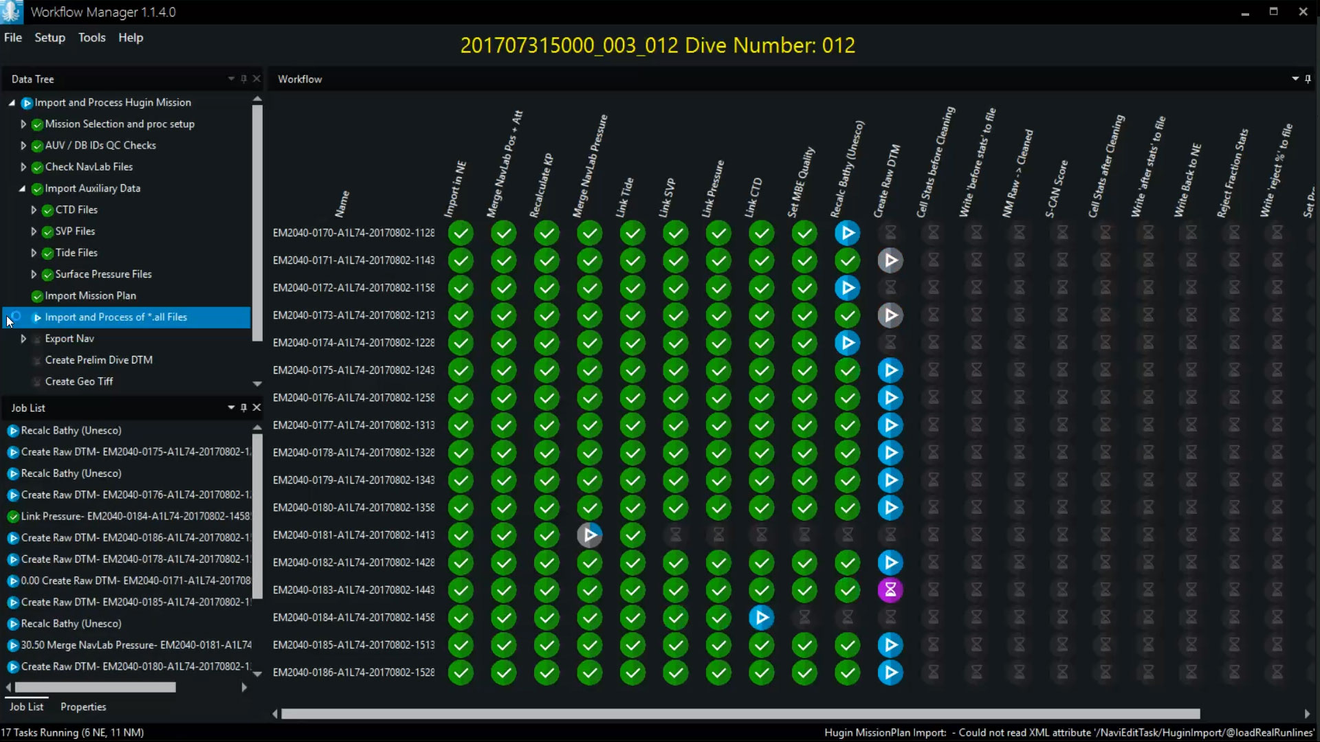
When processing data, the Workflow Manager will visually show the operator which steps are being performed and their status by icons:
- Current steps (blue): The currently running step(s) that are executed in parallel. You can define how many parallel tasks the Workflow Manager should use to ensure that it matches the capacity of your computer.
- Completed (green): The step has been completed successfully.
- Error (red): When an error is encountered, the processing of the specific step stops, and the operator can decide what to do by investigating the error in NaviEdit/NaviModel, manually change the data as necessary, and restart the automatic processing from a given step.
- User action (yellow): The tool can be set up to stop at a given point when carrying out a specific task. This is useful for processing steps that require manual quality control or steps that require operator-provided data or interpretation before the task can continue.
All processing steps are logged. This means that the Workflow Manager provides a fully detailed survey log for later use, showing what was done by an operator or the tool and with what result.
Keeping an eye of processing performance optimisations
The Workflow Manager has a built-in performance measurement tool that measures the time spent on each processing step, so it is very easy to see how much time each part of the workflow takes, and consequently where it is worth optimising.
-
Automatic data processing tool
Save time on data processing by automating your workflow – using NaviSuite Workflow Manager, designed to enable a previously unseen degree of automatic data processing of massive amounts of subsea sensor data.
Automatic processing features
The NaviSuite Workflow Manager tool is designed to enable a previously unseen degree of automatic data processing of massive amounts of subsea sensor data.
AUV processing workflow
The first version of the Workflow Manager utilises NaviEdit and NaviModel for a traditional survey data set processing of data from AUV dive. As soon as the data is available, it is automatically loaded into the flow and processed by cleaning data, merging reprocessed AUV track, building DTMs and making sanity checks. This is typically done using the Server version.
NaviSuite Kuda processing workflow
The Workflow Manager desktop version is very well suited for NaviSuite Kuda operations where each file will be processed right after recording, thus enabling reporting and quality control as you go. The Desktop version runs one task at the time – but it is more than fast enough to cope with survey speed.
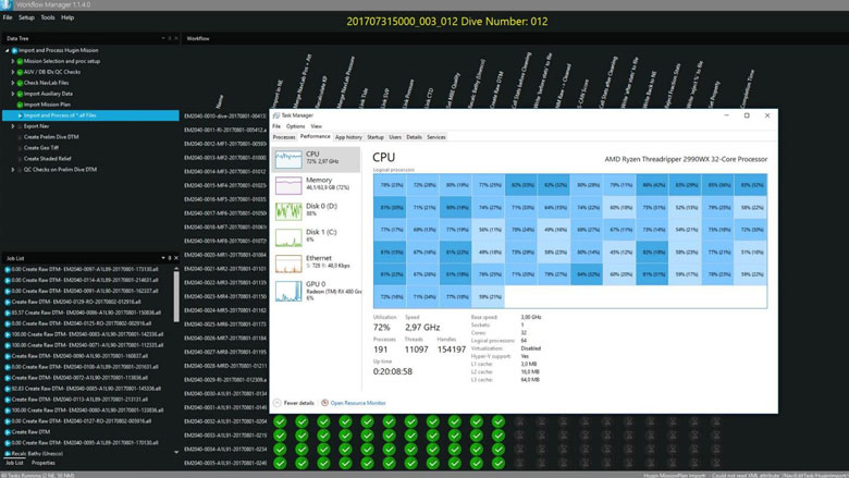
Execute multiple parallel NaviEdit, NaviModel and 3rd party commands
The more CPU (cores), memory and disk speed you have – the better you utilise the workflow engine. The optimal solution is running a bit fewer processes than the number of cores.
-
Optional extra services and special offers
EIVA offers a number of services for our NaviSuite software users.
Optional extra services and special offers
Get the most out of your software
EIVA offers a number of services for our NaviSuite software users. These include:
- Access to our self-service licence administration and purchase portal, My EIVA
- eLearning, virtual and classroom training
- Software maintenance and 24/7 support programme (Comes free of charge for subscription licences – Learn about the different licence types and the maintenance and support programme)
- Custom development
- Mobilisation/installation – on-site or remote assistance
- Dongle replacement programme for lost or broken dongles for permanent licences
Also, we have a number of special offers:
Variant comparison
Related products
-
NaviEdit Lite
Editing of single source output and positioning data such as data from single beam echo sounders and magnetometers, as well as positioning solutions.
€ 15.00/day€ 908.00/year€ 2,725.00/permanent -
NaviModel Producer
Full software solution for data processing, cleaning, modelling and reporting.
€ 81.00/day€ 5,008.00/year€ 15,025.00/permanent -
Workflow Manager – Server
Configurable workflow process automation tool allowing for automation of the small steps you normally go through when processing subsea data.
€ 13,650.00/year