The power of virtual buoys – how they reduce costs and increase safety
Paying the price and the challenge with buoys
In 2018, Odense Port (formerly LINDØ port of ODENSE) approached EIVA with a problem and the desire to develop a solution. They had approached other manufacturers before EIVA, but without success.
Odense Port is located on the island of Fyn, Denmark. The port has important ties to offshore wind farm operations and the clean energy that provides many Danish homes with power. Whenever a large vessel arrived at Odense Port, they would deploy an armada of 21 physical buoys to aid with navigation through the complex channel. When the vessel set sail, they would take all 21 buoys back in again. The process of deployment, collection, and maintenance to mark out the deepest part of the channel would often occur on a weekly basis and cost Odense Port approximately 1 million Danish Krone a year (135,000 EUR).
Leaving the buoys out as permanent markers was not an option. Firstly, the deepest part of the channel tends to move, as is common where currents and sediment deposits exist. Secondly, the buoys were exposed to the elements and potential damage from smaller vessels. This is where the problem was anchored, between the shifting channel, the desire for safety, and the protection of equipment. Denmark is known for its harsh winters. Storms and ice created wear and tear on buoys while the grim weather posed a risk to the boat and crew whose task it was to deploy and collect on a weekly basis. A new solution to the situation at Odense Port was required.
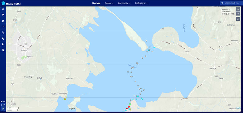
The deepest part of the channel marked out at Odense Port – image courtesy of Marine Traffic
Buoys, unlike fixed beacons, are easily manipulated under strong winds and powerful currents, which can lead to a lack of precision during navigation. This issue was also high on the list when developing the solution. The margin of error for navigation is often as narrow as the channel of which vessels pass through – even small inaccuracies can lead to large problems.
This challenge isn’t unique to Odense Port. In fact, anywhere sandbanks, environmental preservation projects such as reefs and corals, or shallow, narrow canals exist, Aids to Navigation (AtoN) are required to safely guide large vessels. Furthermore, companies specialising in oil and gas, offshore renewable energy and utilities, all have a vested interest in the protection of subsea assets such as cables and pipelines. The requirement to mark out hazards and assets to increase safety and reduce repair costs places many industries in the same boat as Odense Port.
Many ports employ physical buoys when addressing the challenge. Buoys have existed for hundreds, if not thousands of years, and are a costly and an unnecessary risk to those involved in their deployment and maintenance, especially in a modern world where technology has already done so much.
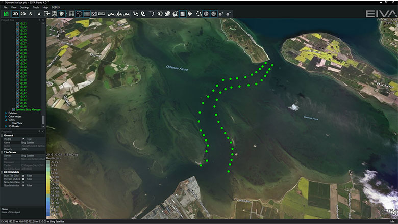
Virtual buoys marking out the safe route for large vessels in NaviSuite Perio software
A virtual solution to a real problem
If it ain’t broke, don’t fix it. To replace a working system with another, especially one as recognised as an international standard like marker buoys, could be considered over-engineering. Therefore, the answer was to reshape instead of replace. The solution involved using software in a new way, harvesting the possibilities provided by modern technology, like many other software applications which are reshaping the world around us.
Every vessel over 300 tons must have an Automatic Identification System (AIS) transponder to broadcast its position, and receive the position of other large vessels and hazards within the vicinity. Most ports employ permanent markers to guide ships and utilise the AIS system to mark out the position of any hazards. The R&D department at EIVA decided that rather than over designing the solution, they would incorporate existing systems and technology to allow for integration in every port.
NaviSuite Perio was the solution that reshaped the system. It doesn’t re-design the buoy, or replace it, but makes use of all a buoy’s strengths while eliminating the weaknesses. The software projects virtual buoys where physical buoys once marked out the deepest parts of the channel.
Before planning a vessel’s approach, port authorities upload the latest survey data into NaviSuite Perio and use that as the background to evaluate the existing planned route and to create a safe corridor. This method ensures that decisions are based on up-to-date information. From there, a sophisticated computer rack sitting safely on dry land at Odense harbour broadcasts the position of 21 virtual buoys via AIS to large vessels in need of a channel deeper than 7.5 metres. The virtual buoys are recognised by the vessels existing software just like physical AtoNs. When the navigator looks at their monitor for the safest route, they see virtual buoys appear as if they were real AtoNs.
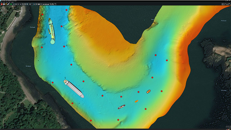
NaviSuite Perio marking out the depth of the channel with virtual buoys and the position of other vessels in the area based on incoming AIS data
NaviSuite Perio listens to incoming AIS data and can display any vessel within range. The system has the ability to display vessels over the latest seabed survey to provide a visualisation of a vessel’s location and direction relative to the virtual buoys while moving through a channel. The display can be advanced to 3D with the addition of detailed drawings or simplified 2D shapes based purely on AIS data alone.
The R&D crew at EIVA understood the need for processing of data from third party surveying software, and designed NaviSuite Perio to do so, even though NaviSuite software is capable of harbour mapping and much more.
In the case of Odense Port, NaviSuite Perio simply points out the deepest part of the channel, but its applications can go much deeper. It can mark out hazardous areas where physical AtoNs would normally be used, and with a virtual buoy, the adjustment of position can be made in real-time, moving it with a just few clicks.
AtoNs are employed by several other industries to alert vessels of no-go areas. Oil and gas companies often electronically mark rigs to highlight any hidden assets to vessels to prevent collisions. Survey and pipelay vessels can tow and lay cables many kilometres in length, which are vulnerable to damage from vessels passing over them. Currently, NaviSuite Perio has the ability to mark out hazards and alert passing vessels, in the future, it will have the ability to record where passing vessels have sailed – in case the data is ever needed.
The physical buoys that were in operation at Odense Port required a boat and crew, who would pull up the anchor point, move the buoy, place a new anchor point, and finally re-attach the buoy before returning to safety. All this to move only one buoy by a few metres. A virtual buoy is not affected by winds or currents, it does not suffer wear and tear, and can be more precise in positioning compared to its physical counterpart.
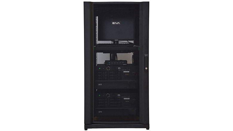
The NaviSuite Perio rack contains the hardware and software needed to create virtual buoys
In the case of a power cut to the harbour, the NaviSuite Perio system at Odense Port is fully redundant, which means all critical components have backups: the PC, antennas, and a UPS (battery) to provide power.
The results of virtual buoys in reality
The need for maintenance and physical adjustment has been cast away. A more efficient system with a heightened level of safety has reshaped a port where an armada of buoys once reigned. Employing virtual AtoN’s and moving them takes a fraction of the time and effort compared to physical buoys, and the costs at Odense Port reflect that.
The deployment and maintenance to mark out the deepest parts of the channel used to cost Odense Port1 million Danish krone annually (135,000 EUR). In the first year alone, NaviSuite Perio saved 75% of the costs. This meant the investment was paying for itself after only 3 months.
When EIVA started the project, we worked closely with Odense harbour, because the project was in the development and testing phase. During this time, the DMA (Danish Maritime Authority) were convinced of the safety and the benefits of the virtual solution, also DanPilot, who are responsible for the safety of all involved when guiding large vessels into Danish harbours. The close collaboration of all parties involved played a role in the successful installation of NaviSuite Perio, and unsurprisingly, several years later, it is still in operation. Odense Port continues to provide a safe and efficient link between dry land and offshore energy operations.

The AIS system used to display virtual buoys on a vessel’s navigational maps
After the application of NaviSuite Perio at any given port, the reduction in cost is very much dependant on the harbour and its own unique challenges. However, with any form of physical deployment and maintenance of buoys and beacons, there is often some shallow water savings to be made and there is always a deep channel available for improving safety.
Products in play
Software
Hardware
- Rack with built-in display, keyboard, etc
- 2 industry rack computers
- EIVA AIS transmitter
- UPS rack unit
- 2 AIS antennas
- 2 GPS antennas
- Standard mounting brackets
- Antenna cables
Facts and figures
The NaviSuite Perio system at Odense Port broadcasts 21 virtual buoys (with as many as 250 available for the most updated version of the software).
Costs of temporary marker buoys were 1 million Danish Krone annually (135,000 EUR).
Odense Port places buoys for vessels dependant on water deeper than 7.5 metres, and they were using 21 physical buoys to do this before NaviSuite Perio was introduced.
75% savings were achieved in the first year, with a return on investment after only 3 months.