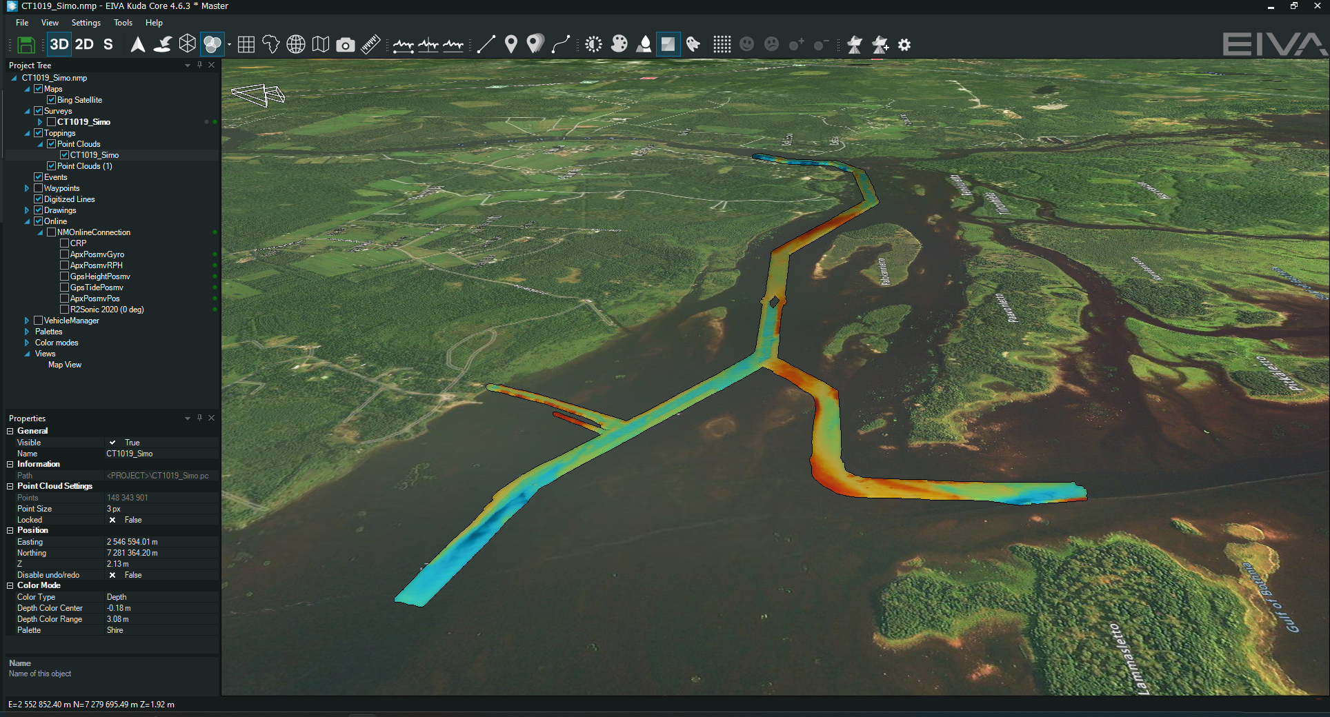
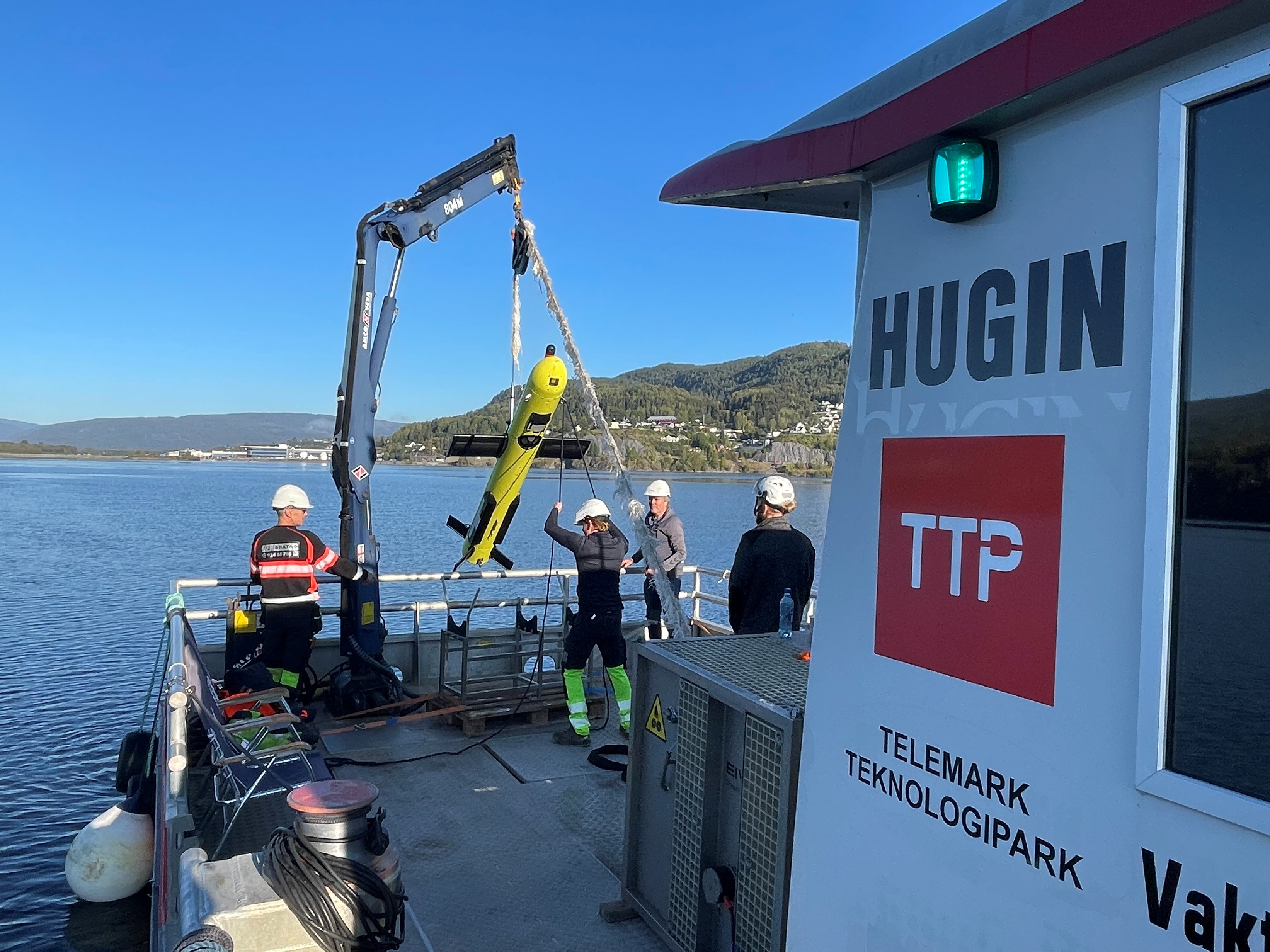
EIVA A/S

To use this site, please enable javascript

References

References

Hear what some of our customers have to say about working with our software and hardware solutions:


NaviSuite software products for shallow water and offshore survey and engineering operations


BP

'The NaviSuite QC Toolbox is a powerful suite of high-performance applications that enables the processing, analysis, manipulation and visualisation of survey, positioning, and site investigation data for BP. The solution replaces several legacy applications, providing users with all of the existing functionality, but with significant improvements and enhancements. It has greatly enhanced the tools available to surveyors and site investigation specialists by facilitating rigorous quality control of the positional accuracy and integrity of data, in order to reduce risk and ensure the safety and efficiency of operational activities. With the ability to consume and export a wide variety of industry data exchange formats, and undertake complex QC tasks simply and efficiently, it is a vital component of any surveyor’s digital toolbox.'
Survey Solutions Manager Josh Townsend

Read more about how EIVA modernised BP’s software solution for the quality control of survey data


DeepOcean

Integrated provider of services and technologies for the subsea industry

'The NaviModel Producer software is with the new generation 4 as stable and innovative as ever.'
Jan Didrik Andersen, EIVA NaviSuite user for more than 30 years and a highly experienced data processor


NPCC Survey

Offshore engineering, procurement and construction company

'Since EIVA software was introduced in NPCC during 2005, it has played a vital role in all our survey activities viz barge positioning, navigation, geophysical data acquisition, ROV and post-processing.'
Shibu Vasudevan, Senior Geomatics Staff


Voyis (formerly 2G Robotics)

'Though we did not use EIVA NaviSuite in a typical fashion it was an easy interface to clean, merge, and visualize all of the data that we had acquired offline.'
Jason Epp, Embedded Systems Developer

Learn how EIVA NaviSuite modelled WWII shipwrecks down to the millimetre together with Voyis


Clinton

Geophysical and hydrographic survey specialist

'Clinton Marine Survey has been using the preliminary version of Workflow Manager since November 2018. As we have a preliminary version, we look forward to its official release with even more functions implemented, but already at this stage we save massive amounts of time for our processors as the repetitive steps such as import, initial QC and filtering, merging of sensors and import to NaviModel DTM files have already been performed. Our processors can then focus on the tasks actually requiring human input, where experience and logical analysis is valuable. We look forward to work closely with EIVA to further develop the Workflow Manager.'
Jessica Ask, Hydrographic Manager

'Clinton used NaviSuite for all our projects during 2016, and will do the same going onward. The strategy to use NaviSuite for hydrographic and offshore surveys has created a smooth processing workflow and increased competence for our personnel by using only one standardised software flow. The client will benefit from higher quality and more cost-effective operations in the coming projects.'
Survey Manager Anders Wikmar

Learn how custom software development made EIVA the single supplier to Clinton


TESSEC

Engineering and Maritime Services

'Ultra-shallow water positioning for stationary scanners is fairly complex and unprecise, especially when operating in a noisy environment such as a busy access channel and shipyard area. When positioning data is unavailable, EIVA’s NaviSuite software provided tools that guaranteed a difficult process was made easy and intuitive, enabling real-time analysis of data collected just a few hours earlier.'
Technical Director Thomaz Tessler

Read more about how TESSEC utilised NaviModel Producer and QuickStitch to analyse and visualise a shipwreck removal from an access channel to an oil and gas terminal


Styvehavn AS

'NaviSuite Kuda is really an important component for us to be able to deliver these inspection services. Particularly NaviModel, which is a modern, fantastic tool to work with. It can display many kinds of data in 3D and allows us to prepare and deliver state of the art survey data to our clients.'
General Manager Henrik Halvorsen

Read more about how NaviSuite Kuda created fast, visual and deliverable data from a harbour inspection


'Thank you EIVA for developing fantastic, powerful software tools. Given the fantastic technology we possess, from a high-end multi-beam echo sounder system to complex and powerful EIVA software, there is so much we can do, so much we can improve to end up with even greater products for our clients.’
General Manager Henrik Halvorsen


Marine Solutions

‘EIVA has developed a system that is unique in handling large 3D files, and the real-time visualisation of these large files is astonishingly fast, making the operation very realistic. The import of point clouds and CAD drawings is drag-and-drop, and data and drawing manipulation is very handy and extremely easy. In combination with NaviPac and IODesigner, all kinds of sensors and values are available for you to play around with.’  
Ben S. Johnsen, Manager


Tilone Subsea Limited

Marine contracting, inspection, maintenance and repair, engineering and environmental services company

'EIVA software is one of the best hydrographic survey software solutions I have worked with due to its flexibility and user-friendliness.'
Obadaye Daniel, Project Surveyor

Aertssen Group

'We are very satisfied with the support from EIVA, as they are truly always available and have been great at helping to find solutions tailored to our needs.'
Chief Surveyor Sven Goovaerts


Digital Horizon Company Limited

Surveying, hydrography and engineering specialist

'Our navigation software has been and still is EIVA; our clients are pleased with this especially with the ease of interpretation. The software is also user-friendly.'
Akhigbe Klein Irenen, fnis JP, Managing Director

'The EIVA NaviModel tools for cleaning bathymetric data have been and remain the most powerful and rapid tools available.'
Mohamed Hashem, Offshore Survey Dep. Manager at Maridive Offshore Projects, NaviSuite user for 15 years 


'With the updates made on NaviPac 4.0, EIVA, in my opinion, is now in a league of its own within the hydrography and maritime software market. I have not seen a UI that impressive or had a UX that intuitive and simple. I am convinced that innovation is king at EIVA. Great work!'
Uchechukwu Philemon Obimma. Hydrographic Surveyor, Freelancer


LINDØ port of ODENSE

'We have been working with EIVA and NaviSuite Perio for several years now. The virtual buoy system is a perfect solution for the temporary marking of our secondary fairway. The system provides both cost and time savings compared to our old physical method of marking the fairway. In our case the payback time of the system has been less than a year, which means that the decision to make the investment has been a no brainer. As the digital wave hits the maritime industry, we predict more possibilities and benefits for the use of our virtual buoy system in the near future.'
Harbour master Kim Kroun

Read more about the power of virtual buoys – how they reduce costs and increase safety


Green-Bay Project

Seabed cleanup projects along the Skagerak coast

'Green-Bay Project has received invaluable help from EIVA, and we really appreciate the constructive support. We continuously add technology to our workstream and our efforts toward a better coastal environment and the sustainable use of marine resources. EIVA’s NaviSuite software seems to be the best platform for integrating our survey data, subsea operation, and vessel instrumentation, and we are really happy that we can do that under the current agreement.'
Project Manager Tord Aslaksen


'NaviModel is my go-to solution both for planning and processing. It's stable, reliable, and lets you process huge amounts of data seamlessly (even on PCs that are not so sharp anymore). NaviModel also reduces the time you spend processing. For example, in one project I was asked to use a different program to do the processing and NaviModel to merge the processed lines. Once the project was finished, I tried reprocessing the whole dataset using only NaviModel. This took only one-fourth of the time compared to before. NaviModel works well with data coming from other survey software and even better if you use it in the NaviSuite ecosystem. As a surveyor, I expect EIVA will be probably leading the market in the next years.’
Umberto Guardascione, hydrographic surveyor


First Marine Solutions

Temporary and permanent Mooring solutions for floating offshore units

'When we were assessing what software package to go with, EIVA a/s was a clear choice. It is able to undertake any hydrographic survey operation, both traditionally or remotely. Utilising NaviModel for our client deliverables supports everything we are striving to achieve here at FMS Survey.'
Survey and Positioning Manager Carl Lafferty


'Our ROV’s flight characteristics are amazing when using the control software in NaviSuite Mobula. With this software, the ROV now does everything I was hoping for.'
Kelsey Treloar, co-managing director at Southern Ocean Subsea PTY Ltd. 


'This past season I have been using NaviPac 4.5 for surveying and I more than approve of this latest version! NaviPac is truly the best navigation and positioning software on the market. As a surveyor, there are many tools and features I love to use in NaviPac. A quick tip for other NaviPac users, I have saved time on my tasks by configuring shortcuts to quickly access the tools I use most.'
Jeogan Nascimento, freelance online surveyor and survey engineer


'We have been using NaviSuite Mobula for our ROV (BlueROV2) for 9 months or so and in that time, we have used it for several successful projects. The setup is user-friendly, and we’ve received great support. We like the piloting features like auto depth and auto heading, as well as capabilities like recording footage, integrating navigation equipment (USBL), extra settings for adjusting gain and displaying a variety of information on the screen to help the pilot.'
Paul Storey, ROV supervisor and director of Below and Beyond Ltd


TideWise

Autonomous USV startup

One of the things we really like about NaviSuite Kuda Core is the ability to easily make real-time 3D data displays – which enhance the perspective of operators of our USV. NaviSuite’s online interface allows surveyors to immediately view the results – and from any angle.
Another thing is that
 I found the setup configuration user-friendly and easy to adjust as required. It’s very intuitive.
Douglas Nemes

Learn more about TideWise's USV running NaviSuite Kuda Core + Processing


AkerBP

A great thing about NaviModel is that you can drop big terrain models in no problem. In projects where we have data sets that range from 1 week to 20 years old they can all be dropped in, and form a patchwork of terrain models, which is really helpful and provides huge benefits.
Matt Cowing, Operations Surveyor at AkerBP


‘During our August 2022 field campaign, we successfully tested the EIVA NaviSuite Mobula Sonar software’s automatic and assisted steering capabilities including Keep Distance. Using this steering mode, with data collected by the Ping360 in real time, our ROV could hold its position relative to an iceberg a specified distance away.
We received exceptional support from the EIVA team in getting the software to meet our group's specific needs for our first field campaign and we believe that this software has the potential to increase the capabilities of the ROV for studying glacier melt. Our next steps will be to continue to work with EIVA to explore how we can use data from other instruments mounted on the ROVs, like DVLs and underwater acoustic beacons, to increase our control of the ROVs.’

Nadia Cohen, Graduate Student at Oregon State University


Hardware solutions, such as the ToughBoy wave buoy and ScanFish ROTV

 wpd

'wpd found with EIVA a flexible and proactive partner to fully satisfy the project's demands. Together, we were able to develop a solution with a unique form of mitigating the risk of having data leaks at an affordable price rate.'
Project Manager Offshore Logistics Florian Lesch

Read more about how EIVA arranged both data security and savings on ToughBoy Panchax wave buoys for a client's offshore wind farm project


WSP

'We have been very happy with the ToughBoy wave buoy and EIVA’s support team. The buoy works just as we hoped for. Even without being a technician, we found the ToughBoy was easy to assemble and use. We pretty much didn’t have to do anything more than put it in the water.'
Technical Director Ole Smith

Read the full bridge construction case study


Bibby HydroMap

'In the last 18 months, Bibby HydroMap have been commissioned to conduct several large UXO surveys across Europe – development of our towing setup to incorporate multiple EIVA ScanFish enables us to react to a range of differing client requirements on each project with no loss of efficiency between sites.'
Operations Manager Tom Davenport

Read more about how Bibby HydroMap brought innovation to UXO surveying with a multiple EIVA ScanFish setup