To use this site, please enable javascript
To use this site, please enable javascript
Recently, some of the major oil and gas operators have been making it a requirement that survey data is delivered in the latest standard data exchange P format. P formats are the best practice standards for survey data, as defined by the International Association of Oil & Gas Producers (IOGP). To match our customers’ needs, it was natural for the EIVA crew to implement support for these formats, providing a fleet of benefits for our NaviSuite users.
The IOGP’s members produce 40% of the world’s oil and gas – and they know from experience that subsea asset survey data must often exchange hands. To make these exchanges go smoothly, they developed the P formats, which are used by contractors to submit their survey data to operators, operators as they pass data between interested parties and even regulatory bodies such as the UK Department for Business, Energy & Industrial Strategy.
The P format series helps ensure that your survey data files contain all the information you need. For example, in all P format files there is a header where you record information necessary for data exchange between different parties and software, such as operational and geodetic parameters.

EIVA’s software development team has recently added the option to import P format data, particularly P5/94 (pipeline position) and P6/11 (seismic bin grid) data into NaviSuite. In our high-performance data modelling software solution, NaviModel, customers can visualise and quality control P5/94 and P6/11 data – let’s dive into how…
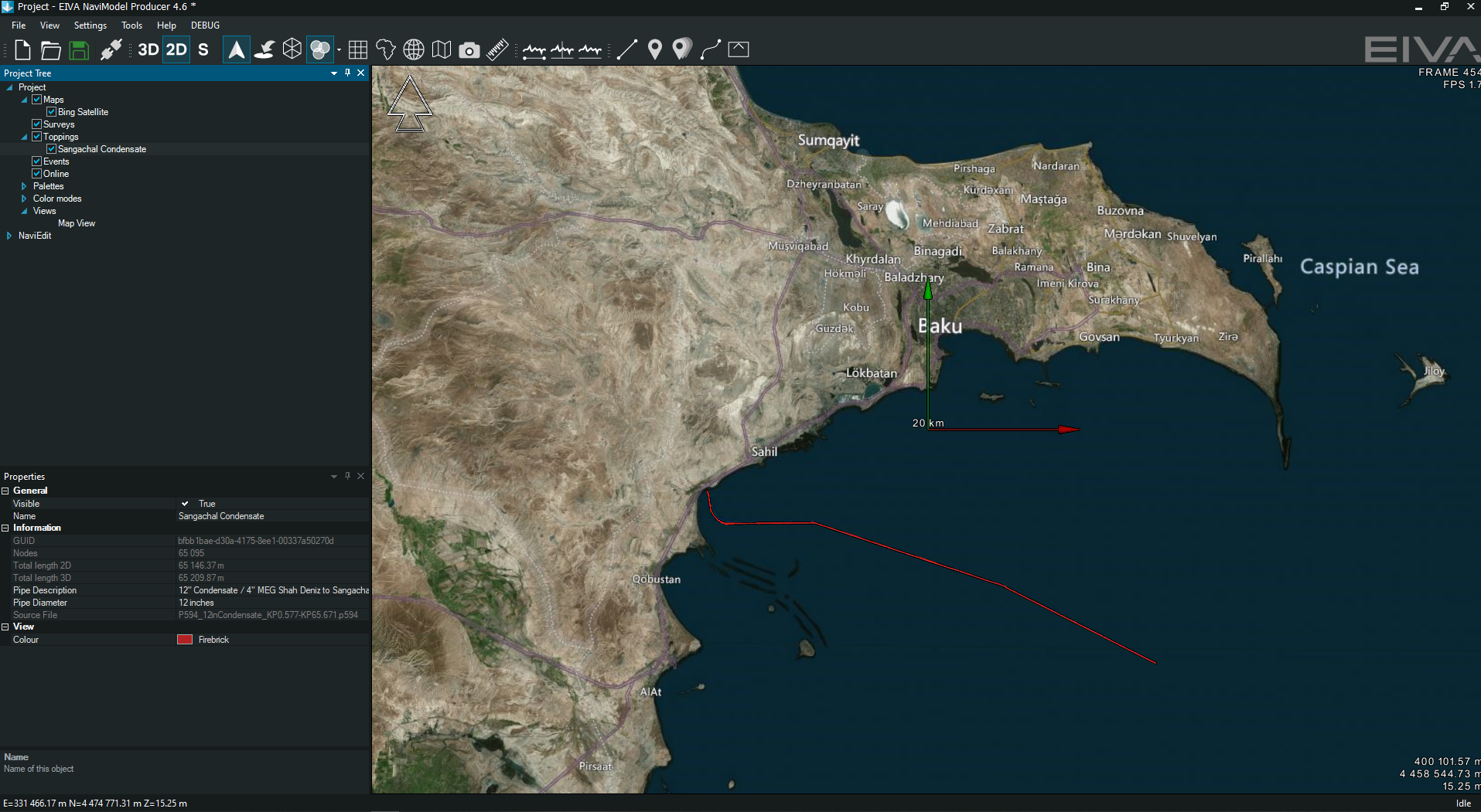
Firstly, the file format for pipeline position data, P5/94, allows users to load existing infrastructure into their open project and display it with other survey data or information. During data loading, our software automatically checks the header data mandated in the format standard to ensure geospatial integrity with the NaviModel project settings – a warning for the user will be displayed if any issues are detected.
Below is a map in NaviModel, where the red line displays a pipeline directly imported from a P5/94 format file. In the properties window, data extracted from the P5/94 file is automatically displayed, such as the pipeline name, diameter and source file.
Secondly, the file format for seismic bin grid data, P6/11, lets users import the seismic position data into NaviEdit, our software solution for survey data editing. During import, a quality control (QC) report is generated which can subsequently be viewed in NaviEdit and NaviModel. Issues highlighted in the QC report are found through various automatic checks on the data, for example checking the orthogonality of the defined bin grid or the definition of the defined units and any example points supplied to test the geodetic integrity of the data.
NaviModel lets users visualise the imported seismic survey bin grid as well as any included definitions of data perimeters, such as the survey data extent and the full fold coverage. If the positions of the seismic data have been re-processed, the visual display of the individual bin nodes will highlight the effect of any re-projection or transformation on the orthogonality of the original bin gird.
The ability to visualise any distortion will assist users during the QC process in deciding if a re-binning of the data is required. Various visual aids are also provided to the user to highlight if there are any discrepancies in the imported geodesy settings for the seismic bin gird in comparison to the NaviModel project settings – thereby helping to ensure the geodetic integrity of all the disparate data in the view.
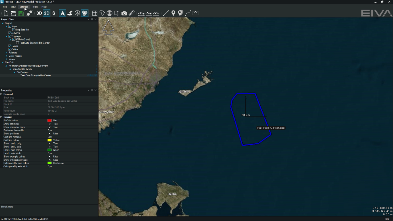
Displaying P6/11 seismic bin grid data in NaviModel
Feel free to let us know if there are file formats you would like implemented in the options of NaviSuite software solutions. Our development team does their best to address our customers’ requests in each software update – customers across the maritime industries, from subsea to above water.
In addition to the P formats, IOGP also develops guidelines, such as the GIGS, a series of guides and test dataset for evaluating geoscience software, which we will dive into in a future log. Stay tuned by following the EIVA cruise.