How EIVA NaviSuite modelled WWII shipwrecks down to the millimetre
Voyis (formerly 2G Robotics)
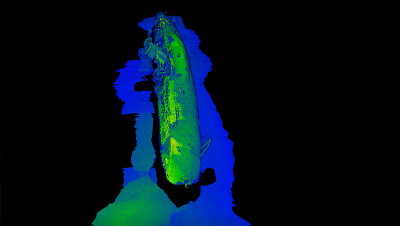
'Flyby' video created using the laser data of the 3D model of German U-576 submarine (Courtesy of Voyis)
Challenge
After years of research, in 2014, the US National Oceanic and Atmospheric Administration (NOAA) discovered the remains of the WWII KS-520 convoy attack off the coast of North Carolina in the Monitor National Marine Sanctuary.
The site of the two shipwrecks – the German submarine U-576 and the American cargo vessel Bluefields – have remained intact and unobserved by anyone since the ships sank to the ocean floor on 15 July 1942. In 2014, only a cursory acoustic survey of the wrecks was possible. As the site is of historical significance it was particularly important not to disturb the site when attempting a more detailed survey.
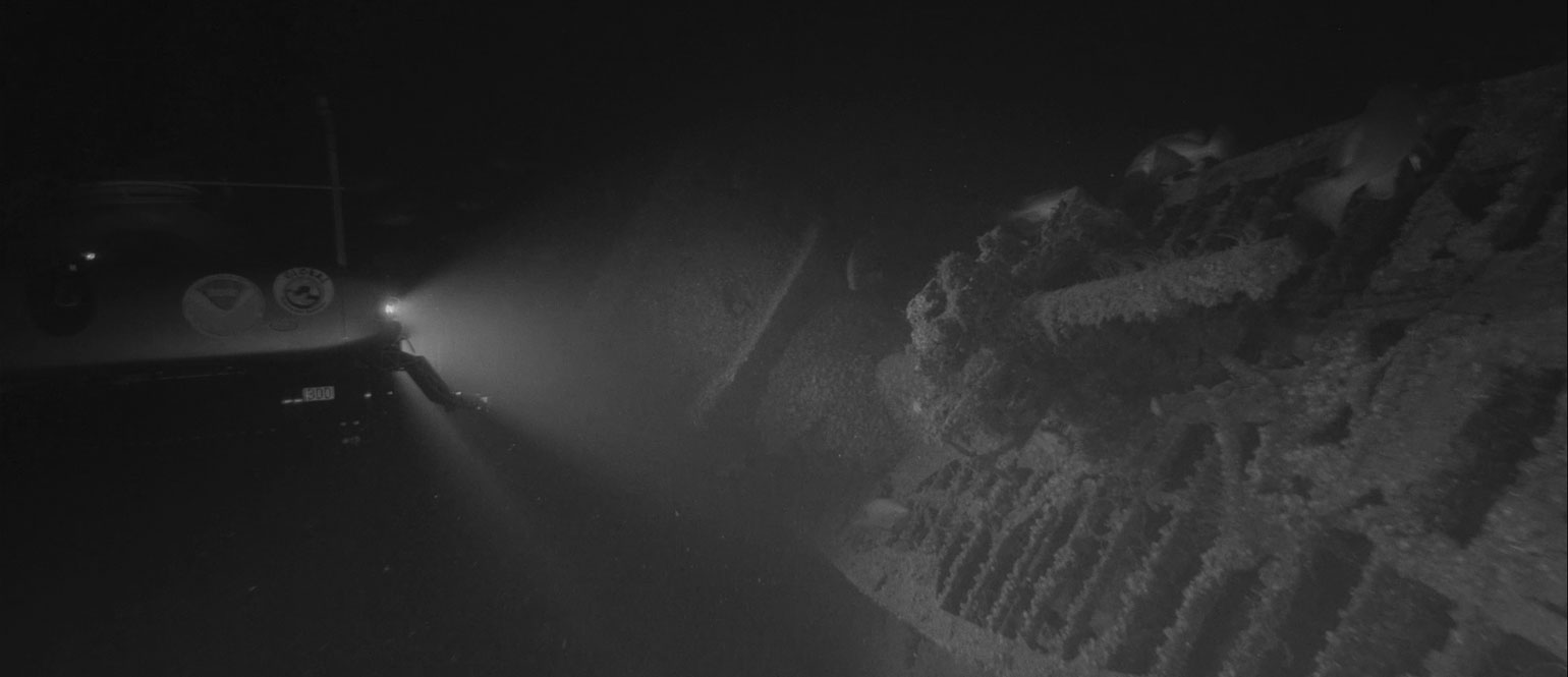
Marine archaeological surveys are particularly hard to pursue at depths like this – about 250 metres – so the ideal survey form should be efficient and fast. Additionally, a software modelling solution was necessary that could interpret the 3D point cloud data fed into it from multiple sensors and devices, so that all obtained data would be easily cross-comparable.
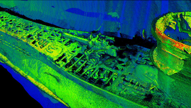
Gun and hatch on the 3D model of the U-boat (Courtesy of Voyis)
Solution
The solution to these challenges was to survey the wrecks with Voyis’ underwater laser scanner and for EIVA NaviSuite to then provide accurate models of these wrecks. The raw laser point cloud data and navigational data from both wrecks was recorded and post-processed through EIVA’s NaviEdit and NaviModel, the NaviSuite products dedicated to data editing and modelling/visualisation respectively.
This method has enabled Voyis to avoid the need to use stitching, thereby achieving greater precision and saving the project valuable time. Moreover, the accuracy of the 3D models created through NaviModel enabled researchers to identify dimensional elements that other methods are not able to detect.
Due to the precision of the data, NOAA will be able to observe changes to the site as time progresses, with a hope to gain understanding of any human imprint on the wreck sites, as well as how the sites act as an ecological habitat to marine organisms.
Moreover, by utilising 3D models of such accuracy, the condition of the site can be preserved as they can be monitored without any physical contact with the wrecks. It is also possible to use the extensive 3D models for virtual interaction with the wrecks for diverse research, educational and programming purposes.
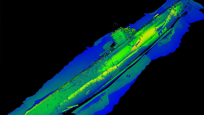
3D model of the German submarine U-576 (Courtesy of Voyis)
Result
In August and September 2016, the wrecks were documented using a Triton 1000/2 two-person submersible, which was equipped with Sonardyne SPRINT AAINS and Voyis’ underwater laser scanner, the ULS-500 PRO. All sensors produced 3D point cloud data, for the sake of successful cross-comparison of the obtained material. The submersible made a total of 16 passes over the wreck, each lasting 7 minutes at a speed of 0.5 knots, over the 65- and 85-metre baselines. However, after just 4 passes, with the ULS-500 PRO positioned perpendicular to the seabed on the submersible, a complete 3D model of the U-576 was already composed.
The raw laser and position data were merged into NaviEdit. The position data was then optimised by georeferencing the point clouds with the help of positioning beacons set up around the wreck sites in a constellation, and after filtering the georeferenced data by intensity, a 3D model display of data was created for visualisation and point cloud editing in NaviModel.
The EIVA NaviSuite products proved crucial in adjusting the positioning of the data, as a result of which the models of the wrecks are accurate down to the millimetre.
Products in play
- NaviModel
3D/4D modelling and visualisation - NaviEdit
Survey data editing - Voyis ULS-500 PRO
Underwater laser scanner - Sonardyne SPRINT
Acoustically aided navigation system (AAINS) - Triton 1000/2
Two-person submersible, 305 metre rated for two people
Facts and numbers
The U-576 and Bluefields both sank 15 July 1942, 56 kilometres off Cape Hatteras, North Carolina, at a depth of roughly 210-250 metres, lying 250 metres apart from each other.
The wrecks form the remains of the KS-520 convoy attack, as part of the Battle of the Atlantic. The Battle of the Atlantic was the longest continuous military conflict in World War II, and it lasted throughout the war in an effort to control the sea routes of the Atlantic.
A complete 3D model of the U-576 was already composed after just 4 passes.
To obtain the laser point cloud data, the ULS-500 PRO was positioned perpendicular to the seabed on the Triton submersible.
The submersible made 16 passes over the wreck in total.
Each pass lasted 7 minutes at a speed of 0.5 knots, over the 65- and 85-metre baselines.