How the Coverage Assist tool automates and optimises surveys
Overcoming the challenges of surveying large areas
With an increase in activities offshore, such as offshore wind farm construction, hydrographic survey area requirements are becoming larger and moving farther out to sea. Surveying a large area can take months and become repetitive for surveyors, not to mention expensive in man hours and fuel. These factors have been motivating the development of solutions enabling automation and autonomous hydrographic surveys, including the Coverage Assist tool, which we are proud to say has served NaviSuite users for over 5 years.
It began as a custom software solution
Njord Survey, a Swedish surveying firm, was seeking to use automation to solve the challenges of surveying large areas, so they reached out to EIVA for a software tool to automate their survey runline planning. Together, we developed the Coverage Assist tool, among other custom software solutions. In 2017, we implemented the Coverage Assist tool in NaviPac, EIVA’s software solution for navigation and data acquisition. The tool has been integrated in NaviSuite Kuda, our software bundle tailored for hydrographic surveys.
Since its release, Njord’s survey teams have been using this tool to automate surveys to a greater extent with huge success…
‘For the past 5 years since the Coverage Assist tool was released, we have been using it for every project we can. It has a big impact on our operations – providing stable, optimal survey coverage and more engaging workdays for our employees as they can focus on tasks needing human knowledge and input.’ – Anders Wikmar, Njord Survey
EIVA’s software solution automatically creates runlines in real-time
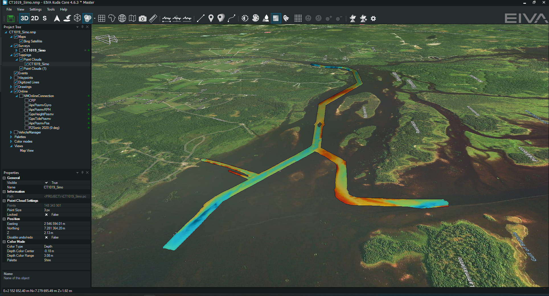
Firstly, let’s cover what the Coverage Assist tool does. Simply said, you define the area you wish to survey, press start and sit back while the software takes the wheel. The Coverage Assist tool plans each runline in real-time – taking into consideration the newly collected survey data to ensure full coverage.
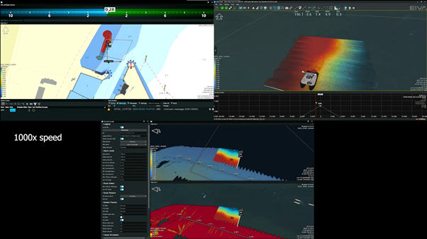
See an example of the Coverage Assist tool in action
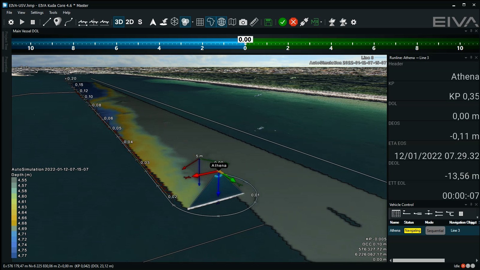
Since the development of this tool, EIVA’s offerings supporting automated surveys have been expanded. This means that you can now use NaviSuite Kuda software, which includes the Coverage Assist tool, to control a USV (either through a standard NMEA autopilot or the NaviSuite Kuda - Autopilot).
The results benefit survey operations and operators
Over Njord’s years of using the Coverage Assist tool, Anders Wikmar has noticed there are two main ways in which the Coverage Assist tool makes a difference for their surveyors: improving coverage when there are unpredictable heading changes and increasing well-being when surveying large areas.
Mind the gap – optimising survey area coverage
When there are unpredictable changes in heading, for example due to the weather and currents changing, the Coverage Assist tool efficiently calculates optimal runlines – saving time and fuel.
‘Heading changes during surveys are a big problem, as they are difficult to manually correct for, but the Coverage Assist tool can do it smoothly – ensuring there are no gaps. This tool is a far more efficient alternative to how you otherwise have to deal with such conditions manually: by redoing any parts of the survey with a gap or increasing the overlap between runlines to prevent gaps occurring.’ – Anders Wikmar, Njord Survey
Let surveyors take coffee breaks and do engaging work
At the time of writing, Njord’s vessel Northern Storm is performing a survey of a 950 km2 area for an offshore wind farm site. When Njord is surveying a large area like this, the Coverage Assist tool makes an especially big difference, both for achieving consistent, optimal coverage but also for their surveyors’ well-being. Over the course of months working 12 hour shifts, manual steering tends to become tedious.
‘The Coverage Assist tool frees up our employees from manual steering, so they can focus on other tasks that require their knowledge – this keeps them engaged and interested.’ Anders Wikmar, Njord Survey
Not only is it tedious to manually steer for that long, but it’s impossible for a human to be fully attentive all the time – since they deserve (and need) some breaks. As Anders Wikmar points out ‘the Coverage Assist tool never goes for coffee!’. This automation tool leads to both more reliable results and better working conditions for surveyors.

One of Njord’s survey vessels moored alongside an island in the archipelago on the west coast of Sweden
Sailing forward with the Coverage Assist tool
EIVA’s customer-centred cooperation in developing custom solutions like the Coverage Assist tool is one of the reasons Njord Survey has used EIVA as their single software provider since 2016, thereby ensuring a streamlined, standardised software flow.
‘EIVA makes sure that as Njord Survey’s projects evolve and progress, the software does too, so that needs are promptly met both now and moving forward.’ – Anders Wikmar
The Coverage Assist tool has also evolved since Njord Survey began using it. As of 2022, the tool has been updated to let you define exclusion zones to avoid. For example, if there is a docked ship or construction site in your survey area which you want to avoid, Coverage Assist can be told to avoid it!
‘I look forward to trying out this new version of the Coverage Assist tool, since the exclusion zone capability means that we will be able to use the Coverage Assist tool in areas with obstructions, in addition to the open areas we have used it for so far.’ – Anders Wikmar, Njord Survey
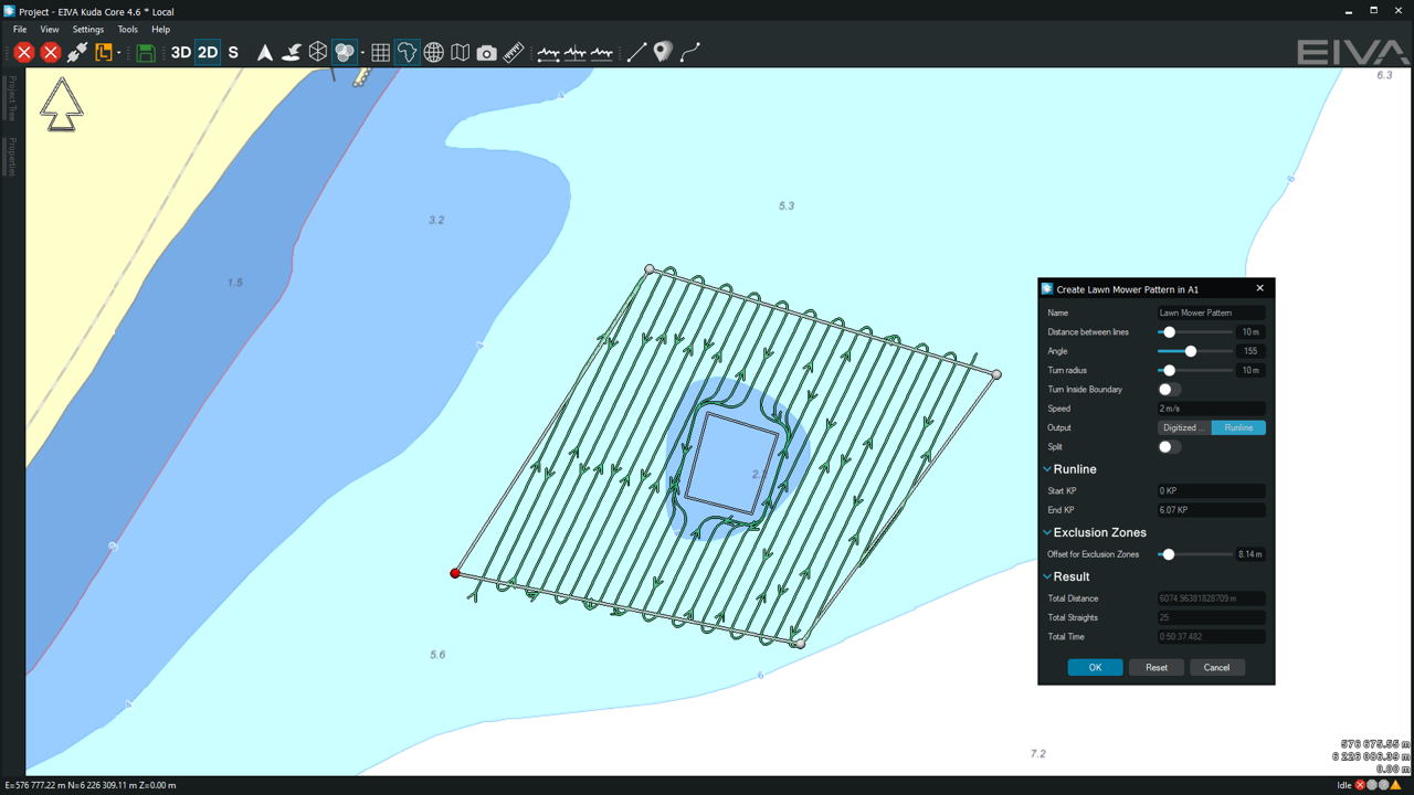
Exclusion zone defined within a lawn mower runline pattern – another new development in NaviSuite Kuda
The NaviSuite fleet of tools for autonomy
While the Coverage Assist tool automates survey coverage optimisation, NaviSuite includes many more tools to automate surveys all the way from survey planning to data processing, whether for entry-level survey setups or complex ones. EIVA also develops advanced survey automation tools drawing on the latest technologies, including AI and computer vision.
Products in play
Software bundle supporting hydrographic surveys all the way from planning and acquisition to data processing and delivery, while enabling automation and remote operations – available in several variants for different budgets and survey setups
Timeline of EIVA’s survey runline planning tool developments
~1990: Planning runlines and waypoints manually
2010: Planning runlines with automatic area coverage using parallel and cross lines
2017: Coverage Assist tool for real-time automatic runline generation
2020: Lawn Mower Pattern tool for automatic runline pattern planning
2022: End waypoint and exclusion zones capability added to both Lawn Mower Pattern and Coverage Assist tools
Want to read another case study on custom software development for surveys? Or dive into a harbour survey case study?