How TESSEC utilised NaviModel Producer and QuickStitch to analyse and visualise a shipwreck removal from an access channel to an oil and gas terminal
A challenging shipwreck removal
Shipwreck removal can be a complex affair, but when wrecks are identified in busy access channels, there can be little alternative. The removal often involves surveying, pre and post dredging, subsea cutting, heavy lifting, and archaeological cataloguing. The amount of equipment and people required is proportional to the level of knowledge around the submerged structure, the extent of sedimentation, structural integrity and archaeological value. It was during investigations for the Niteroi terminal access channel deepening project (2013-2014) in Guanabara Bay, Rio de Janeiro, that a shipwreck was discovered. Initial bathymetric surveys revealed that the vessel’s remnants exceeded design depths for the channel, prompting what became a 41-month removal operation.
Ironically enough, the wreckage – that of a 75 metre, 27 tonne vessel, identified as the Madeira I steamer ship, which sunk during the Armada Revolution (1893-1894) as a result of a grenade explosion – had resided unbeknownst to all for over 100 years just a stone’s throw from the national hydrographic survey institution.
TESSEC Engineering and Maritime Services had the tools, experience and technical staff to perform a shipwreck removal in shallow water and was consequently brought in to conduct surveys and map the wreck, and to deliver designs for the removal operation.
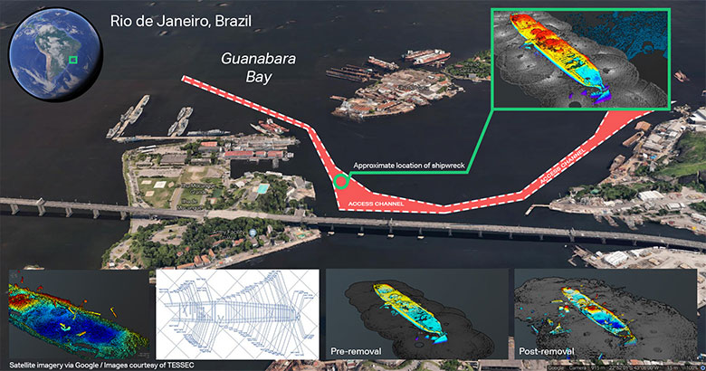
Satellite image of the access channel with 3D images of the wreck and its approximate location
The handling of the Guanabara Bay wreck offered particular challenges of its own, as Thomaz Tessler, Technical Director at TESSEC, explained: ‘Shipwreck removal isn’t common in Brazil, and partly for this reason, very detailed plans for the removal, guided by high resolution survey data, had to be provided to the relevant Brazilian authorities.’
A high resolution, circular scan multi-beam shallow water survey had not been performed for a shipwreck removal operation on the Brazilian coast before, therefore, obtaining and establishing survey standards was an extra requirement. Furthermore, TESSEC required a design and investigation plan aimed at assessing the technical needs for the operation in order to acquire a licence from the relevant authorities to remove the wreck. After the initial survey, the ship’s identity was not established, therefore, its unascertained historical importance lead to a higher degree of oversight from the historical institute.
A solution with multi-beam mechanical scanning sonar and smart software
TESSEC began with preparation and surveying. In order to provide maximum detail and resolution of the shipwreck, TESSEC decided on a mechanical multi-beam sonar solution. Thomaz recalled: ‘Only one model of such equipment was available in the country, a Teledyne BlueView BV 5000 3D mechanical scanning sonar. Various scanning points were planned in order to provide full coverage of the wreckage.’
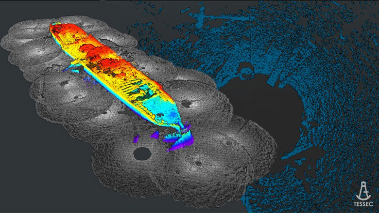
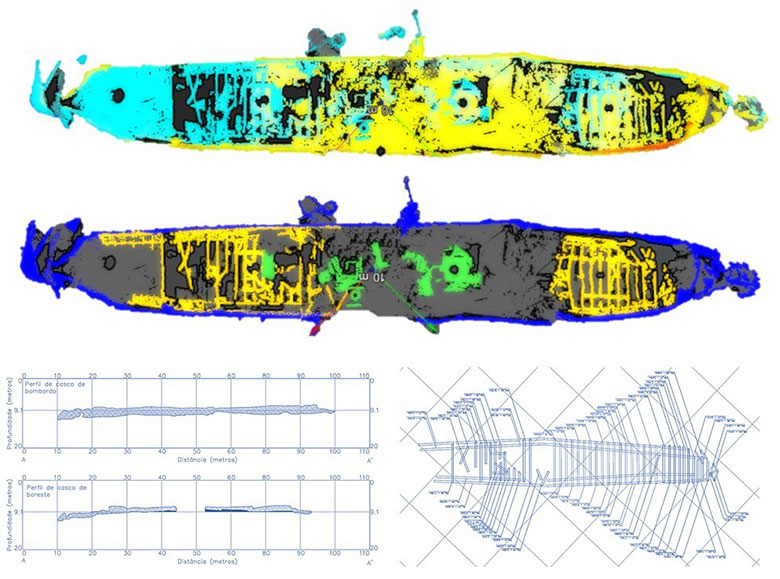
A 3D model of the wreck generated with NaviModel Producer software
To facilitate the surveying, TESSEC looked to EIVA’s range of NaviSuite products. 'EIVA’s QuickStitch software was used throughout the project, enabling real-time, offline analysis of the data quality across our surveys. We also used NaviModel Pro for image generation and to create fly-by movies.’
The QuickStitch software solution is a point cloud viewing, cleaning, and alignment software package, specifically designed to streamline working with multiple point clouds based on XYZ data. NaviModel offers high-performance digital terrain models in 2D and 3D and high-tech tools for model analyses and manipulations. With the NaviModel Producer variant, you get the complete software solution comprising all the features of NaviModel for data processing, cleaning, modelling and reporting.
During the pre-removal survey, cloud points were used to define the dimensions of the elements to be removed. A plan view and a profile view of the shipwreck’s structural situation was defined, separated mainly by hull pieces, structural beam features, and the deckhouse.
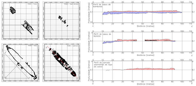
Classification of the structures and profile view of the 3D scanner survey results
'QuickStitch brought us a lot of flexibility, as it meant we were able to review data collected very quickly, and use those findings to plan, and if necessary, adjust the next day’s survey. The quality of the final mosaic created by the software allows you to process the point clouds with great precision and computational efficiency, by altering source angles and position in all degrees of freedom, and easily eliminating noisy data.'
The initial investigations extended to include surveying the pieces of wreck to be removed; listing and dimensioning them to account for hoisting capabilities of the crane available to the project. This work complete, removal operations commenced. The removal was partial, only the sections above 9.1 meters were cut away; these were discarded in a nearby deep section of the channel. Altogether, removal work lasted five months.
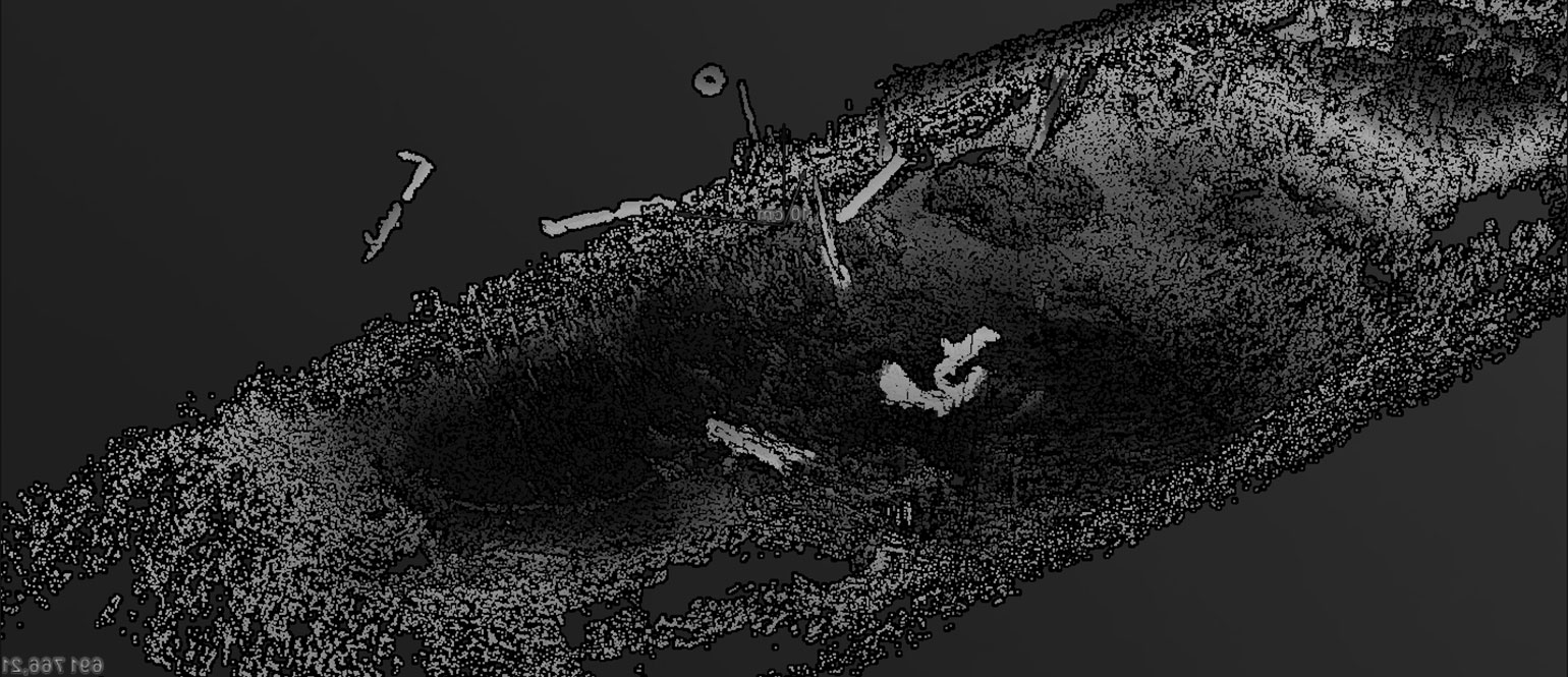
The submerged shipwreck on the seabed of Guanabara Bay, Rio de Janeiro
The results of the shipwreck’s removal
After removal, a final bathymetric survey was undertaken to ensure that the wreckage residue was below the target depth, and a post removal 3D mechanical sonar survey was performed to fulfil remaining archaeological requirements. TESSEC once again utilised QuickStitch’s capabilities for this task. From discovery of the wreckage to a post removal 3D scanner survey, 41 months had elapsed, but the outcome was a resounding success.
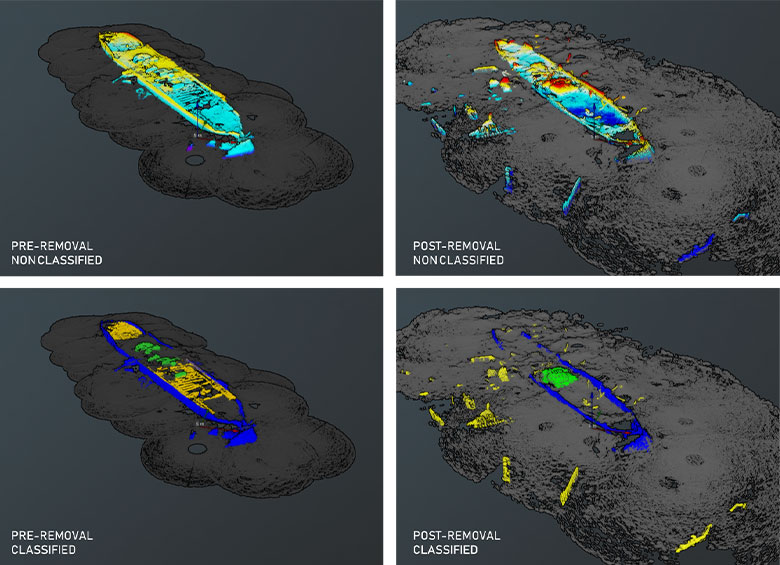
Point cloud mosaics for pre and post removal survey in QuickStitch, the classification of the structures separated into three classes: hull, structural beams and deckhouse
Providing concluding thoughts, Thomaz said: ‘Mapping structures that are submerged for a long period is tricky; particularly once its components (although geometric) are deformed. Therefore, understanding the pieces conformation and assembling the three-dimensional mosaic is a very complex task, and the combination of scan records must be performed with a high level of detail and step-by-step control of inclination and position.’
‘That’s when EIVA’s products are very efficient – providing the tools to perform intuitive processing while maintaining the possibility of parametric data arrangement and recording. The software was essential in providing us high quality quantitative data and, consequently, a successful removal operation. All visualisation of figures, with exception of the plans, were retrieved from QuickStitch, while NaviModel Producer provided all the images and video we needed to document the process.'
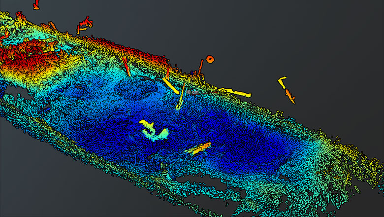
Detail of the deck after the partial removal operation in QuickStitch, modelled in NaviModel Producer
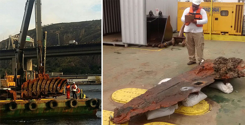
Removal operation: hoisting the pieces that were cut underwater and listing them for archaeological cataloguing
Products in play
Facts and figures
- 75 metre, 27 tonne vessel, discovered on the seabed of Guanabara Bay, Rio de Janeiro, Brazil
- 41-month project (from wreck discovery to project close)
- Average water depth of 7 metres above the wreck
- Only sections above 9.1 meters were cut away
- 1,316 m3 wreck volume removed
- The Madeira I sank during the Armada Revolution (1893-1894)