Hydrographic survey software for efficient, accurate data collection
Hydrographic survey teams work within tight time windows, demanding environments and rising expectations for data quality. Whether the challenge is shifting weather, vessel costs or ensuring complete, reliable coverage, the right software can make a measurable difference in how surveys are planned, executed and delivered.
The NaviSuite Kuda software brings together planning, navigation, acquisition, quality control and processing in one streamlined workflow – helping teams deliver high‑quality results efficiently across harbours, coastal waters and offshore environments.
What is NaviSuite Kuda?
NaviSuite Kuda is EIVA’s dedicated software suite for hydrographic survey operations. It combines survey planning, real‑time vessel guidance, sensor integration, coverage monitoring and data processing in a single, intuitive interface, making it easy for teams to stay oriented throughout the workflow.
Whether you're carrying out a harbour inspection or a large‑scale mapping project, NaviSuite Kuda provides surveyors and data processors with the tools they need to work efficiently and confidently.
As part of the wider NaviSuite ecosystem, NaviSuite Kuda is available in several variants, making it easy to match your vessel setup, sensor spread and budget – and to scale your capabilities as your operations evolve.
Why seabed mapping experts choose NaviSuite Kuda
Workflows that reduce vessel time
Time on the water is one of the highest cost drivers in hydrography. NaviSuite Kuda helps reduce this by making every stage of the workflow more efficient:
Fast runline planning that adapts to survey area requirements
- Real‑time coverage monitoring to avoid unnecessary revisits
- Tools that help surveyors make confident decisions offshore
Automation that ensures consistency
Automation helps reduce repetitive tasks – such as recalculating runlines or checking for data gaps – and supports steady, predictable workflows even in complex survey conditions.
With automation features such as Coverage Assist, NaviSuite Kuda can automatically generate runlines and monitor survey progress, maintaining consistent coverage and minimising the risk of error.
This gives teams more time to focus on interpreting and validating data rather than managing every operational detail.
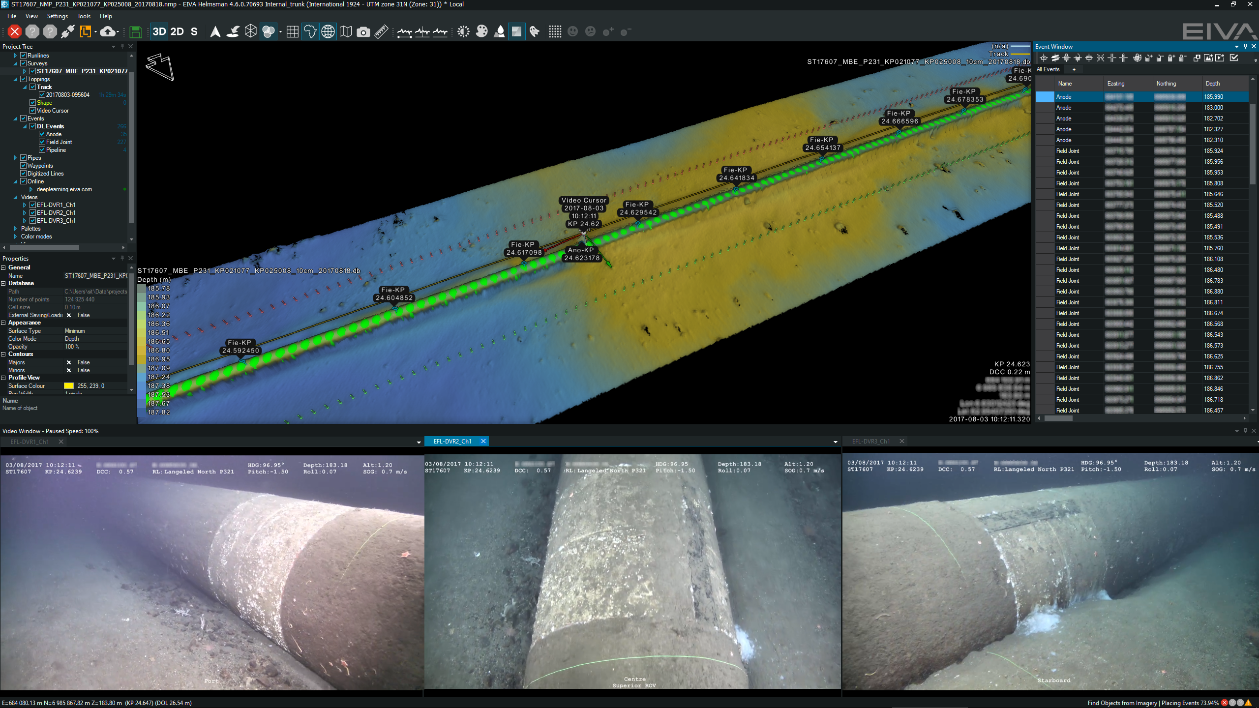
Complete, high‑quality data the first time
Missed data or inconsistent coverage can lead to costly and time‑consuming re‑surveys.
NaviSuite Kuda includes a suite of real‑time quality control tools designed to help surveyors catch issues early:
- Real-time quality indicators
- Alerts for potential data gaps
- Visual feedback on coverage and sensor performance
These tools support faster, more accurate decision‑making both on board and onshore.
Scalable for different survey setups
NaviSuite Kuda adapts to the size and complexity of your operations:
- Suitable for small vessels, USVs and full‑scale survey vessel
- Supports harbours, coastal sites, inland waterways and offshore areas
- Integrates seamlessly with EIVA equipment and a broad range of third‑party sensors
Whether you are building your first hydrographic capability or scaling an established operation, NaviSuite Kuda grows with you.
How NaviSuite Kuda supports each stage of a hydrographic survey
A hydrographic survey typically follows three stages – planning, acquisition and processing – each requiring different tools to ensure complete coverage and reliable data.
Planning
- Rapid runline creation
- Automated line planning with Coverage Assist
- Flexible handling of survey boundaries and environmental constraints
Acquisition
- Real‑time navigation and vessel control
- Integration with multibeam echosounders, positioning systems and other sensors
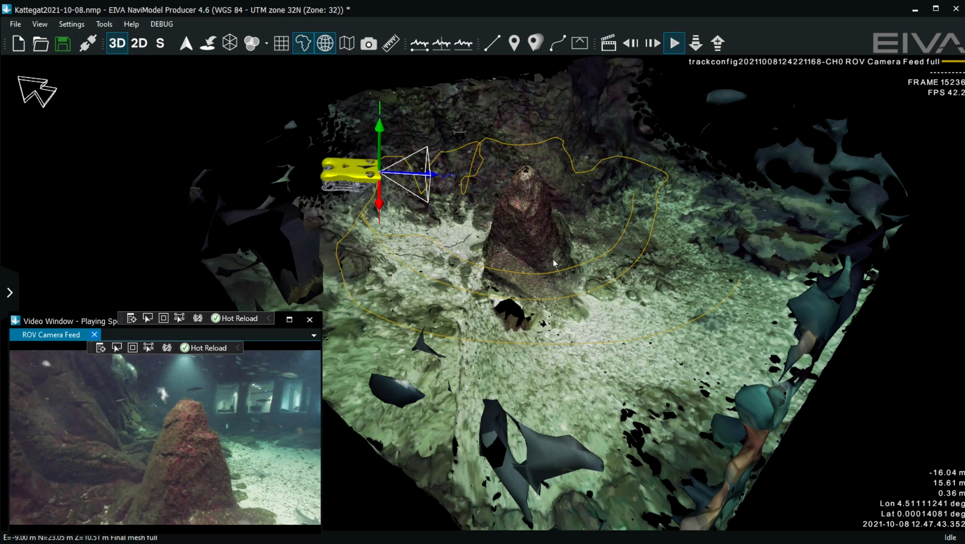
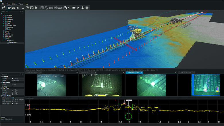
- Real-time terrain model generation for faster QA and reporting
- Real-time QC indicators and coverage monitoring
Processing
- Efficient data cleaning for initial deliverables
- Tools to verify coverage and data completeness
- Export options for standard industry formats
Built for your hydrographic operations
Different survey environments pose different challenges – NaviSuite Kuda is designed to support them all:
- Harbour surveys with tight operational windows
- Coastal mapping requiring high coverage confidence
- USV‑assisted remote and autonomous survey operations
NaviSuite Kuda also supports remote supervision, control and data processing, making it a strong choice for teams working with USVs or distributed survey setups.
Its flexibility and performance make it suitable for both routine tasks and highly demanding projects.
Trusted by hydrographic professionals worldwide
Organisations across the subsea industry use NaviSuite Kuda for reliable, efficient survey results. Many combine it with other NaviSuite products to support advanced operations, such as long‑range remote control, multi‑vessel coordination and autonomous missions.
These examples highlight how NaviSuite Kuda’s tools support both novice and experienced surveyors in managing complex workflows.
'Thanks to its automation tools and user-friendly, streamlined interface, NaviSuite Kuda Core is a great software solution for remote surveys. I have found that the Coverage Assist real-time runline creation tool steers the USV more accurately than a human would be able to, helping the surveyor to ensure efficient area coverage and high-quality data – overcoming challenges of shallow water conditions.’
Kasper Engblom, Technical expert, Civil Tech Oy Ab
'NaviSuite Kuda is really an important component for us to be able to deliver these inspection services. Particularly NaviModel, which is a modern, fantastic tool to work with. It can display many kinds of data in 3D and allows us to prepare and deliver state of the art survey data to our clients.'
General Manager Henrik Halvorsen, Styvehavn
‘One of the things we really like about NaviSuite Kuda Core is the ability to easily make real-time 3D data displays – which enhance the perspective of operators of our USV. NaviSuite’s online interface allows surveyors to immediately view the results – and from any angle.
Another thing is that I found the setup configuration user-friendly and easy to adjust as required. It’s very intuitive.’
Douglas Nemes, TideWise
Explore more or speak with our team
NaviSuite Kuda is part of EIVA’s broader software ecosystem, supporting everything from simple single‑vessel surveys to complex fleet operations.