To use this site, please enable javascript
To use this site, please enable javascript
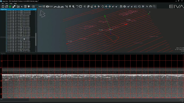
After many requests from our customers, it has been possible to use NaviModel, our NaviSuite product for 3D modelling and visualisation, for sub-bottom profiling data since 2017.
You are able to work with several SEG-Y files in NaviModel at the same time. We are pleased to say that since the initial release, NaviModel now also supports more types of SEG-Y files. When NaviModel is loading the sub-bottom profiling data, the software extracts a rough track that is then taken through a two-step process of extracting a point every 100 metres, and then refined to 3 metres.
The way that NaviModel handles the SEG-Y files is responsive, meaning you do not have to wait for a file to load before you get the details, as shown in the video.
EIVA NaviSuite - Bringing SEG-Y data into the 3D world of NaviModel
Once you get your SEG-Y files imported to NaviModel, you can immediately start moving between different files to see the position track within an overview of the surveyed area. This position is synchronised with the visualisation of the vertical sub-bottom profiles in the SEG-Y View, giving the user an informative overview of the data.
Users can navigate the SEG-Y View with ease via pan and zoom and double-click to move to a location. This SEG-Y View also makes it easy for users to add events to a file by simply right-clicking in the View window. The SEG-Y events created are standard events, meaning that they are in the same location as other event types and can be synced with other types of data as well. Additionally, there is the ability to add a KP in the properties of the SEG-Y View.
If you would like to use NaviModel for handling your SEG-Y data, get in touch with one of our product experts.