How ScanFish Equinox imaged over 80 wrecks with centimetre resolution in Norway’s Telemark Canal
‘Using Equinox, we were able to identify objects of a significantly smaller size than we have been able to previously. These findings include 25 wrecks which we will study further as we suspect they are much older than the ones previously found.’
Thor Olav Sperre
NORSJØ Project Manager
For over a thousand years, the Telemark Canal in Norway has served as an important waterway for transporting goods. This canal links several lakes, and their freshwater conditions help to preserve wrecks – making it ideal to study the history of the waterway through subsea surveys – with sensors such as a multi-aperture sidescan sonar, as used in this case.
Since 2021, the non-profit organisation NORSJØ project has been mapping the well-preserved maritime monuments on the bottom of lakes in the Telemark Canal. In 2022, they used Equinox, a ScanFish solution dedicated to multi-aperture sidescan sonar imaging, to perform a sidescan survey of two of these lakes, Heddal and Norsjø… and they found far more wrecks than they had expected.
‘In Lake Heddal, our survey located 75 wrecks within a dozen square kilometres – this must be the biggest ship cemetery that has ever been located in Norway! We also located five more in Norsjø.’ – Thor Olav Sperre

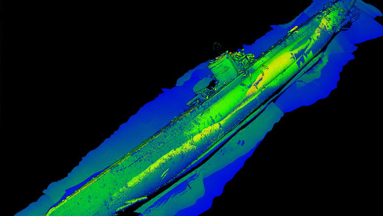
Watch Equinox in action, showing the sidescan sonar images of a variety of wrecks – data courtesy of NORSJØ Project
The challenge of imaging maritime archaeology
The NORSJØ Project team had previously surveyed sections of the lakes with a hull-mounted multi-beam echosounder (MBES). While this was a good tool for general mapping, they wanted to fully illuminate the history on the lake bottom – so they needed to be able to…
- Survey the whole lake, including deeper areas where a hull-mounted sensor is too far from the seabed
- Collect high-resolution data, enabling them to see details and locate smaller wrecks, which are likely older and therefore of great historical interest
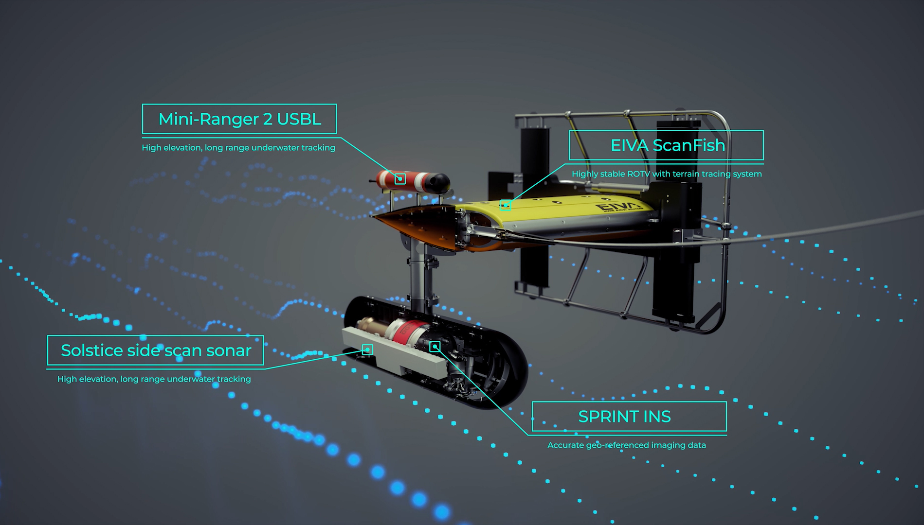
For this, they turned to EIVA. We provided the Equinox integrated solution, combining the stability and control of EIVA’s ScanFish 3D steering and autopilot with the high-resolution data acquisition of Wavefront’s Solstice multi-aperture sonar (MAS) and Sonardyne’s positioning and navigation sensors.
Learn about Equinox
ROTV solution optimally collects maritime archaeology data
High-resolution imaging sensors, such as sidescan sonars, often need to maintain a fixed distance close to the seabed. Remotely operated towed vehicles (ROTV) are an optimal platform for keeping sensors at that sweet spot while scanning large areas efficiently. EIVA’s range of ScanFish ROTV sensor platforms can precisely, automatically follow the seabed at a defined height – offering unrivalled stability to consistently yield high-resolution data.
‘When the seabed terrain changes, the ScanFish automatically adapts to keep the same distance from the seabed – which a regular towfish can’t do. With this platform, we collected far higher quality data than we could have otherwise. The significance of the ROTV platform was even greater in deeper areas of the lakes. For example, the areas we surveyed at around 170 m depth were no problem to image clearly and locate wrecks.’ – Thor Olav Sperre
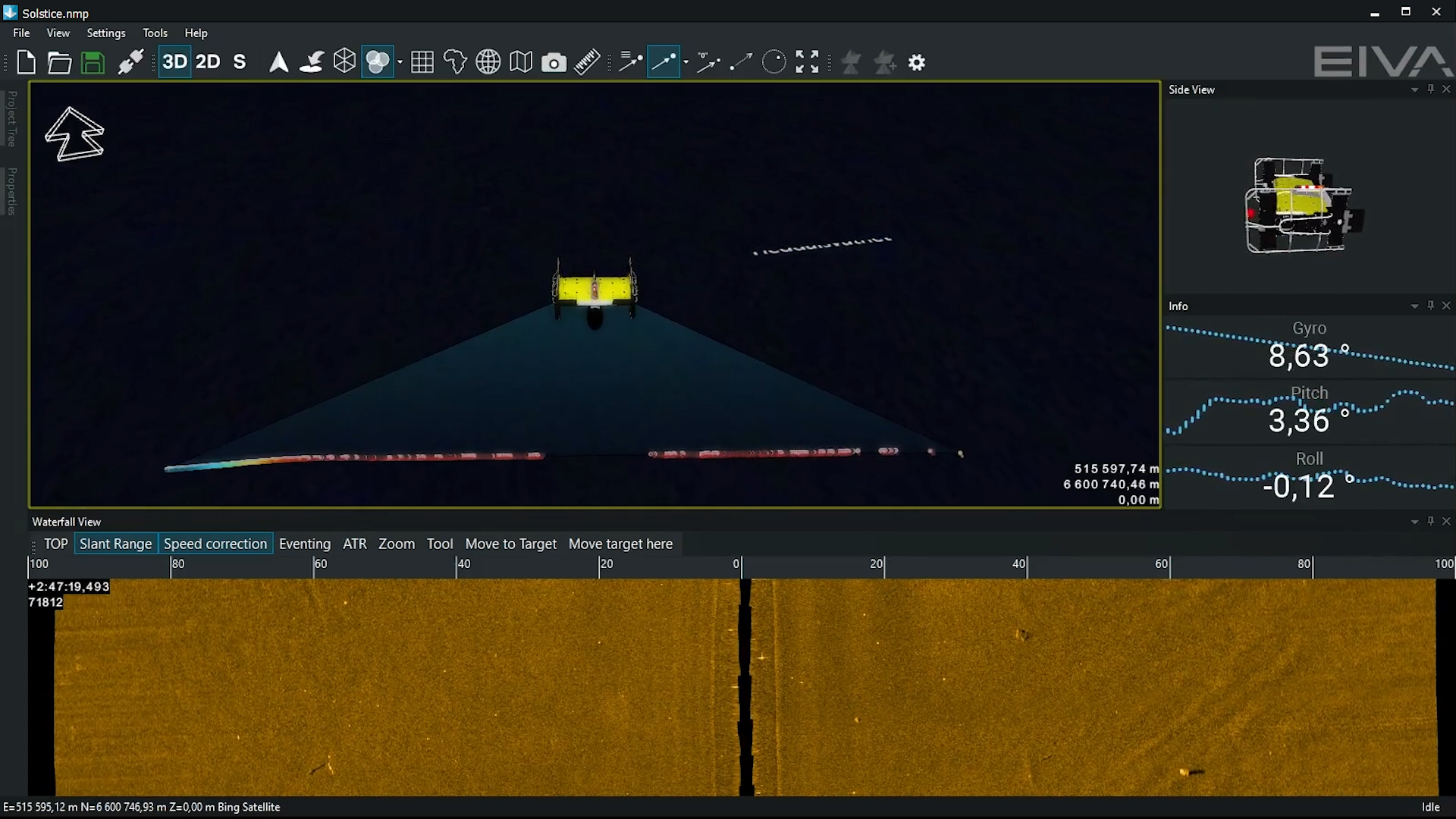
Equinox collecting sidescan sonar data and displaying positioning
Payload matters – multi-aperture sidescan sonar for high-resolution data
Of course, a sensor platform is only as good as the sensors equipped on it.
‘Equinox is equipped with an excellent sidescan sonar – this was one of the things that drew us to it.’ – Thor Olav Sperre
To achieve high-resolution imaging, Equinox features a Solstice MAS. Solstice has a 200 m wide swath for high area coverage rates and has an along track resolution of 0.15° for maximum detection rates. It co-locates sidescan images and bathymetry to improve situational awareness. Combined with positioning data from Sonardyne’s SPRINT INS and Mini-Ranger 2 USBL, this solution ensures accurate and precise high-resolution data collection.
This combination of industry-leading commercial off-the-shelf components from EIVA, Wavefront and Sonardyne results in a joint solution that leverages the strengths of each of these sister companies in Covelya Group.
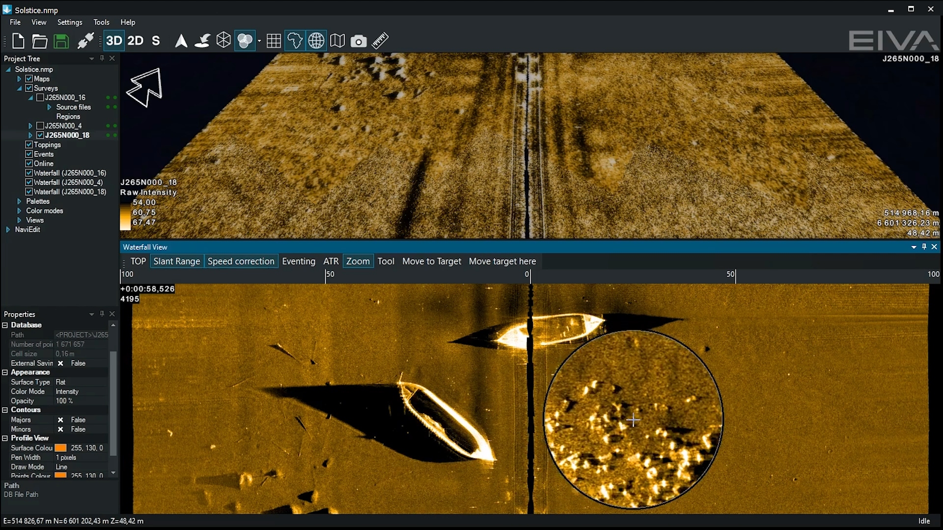
Check out the high resolution sidescan sonar imaging achieved in NORSJØ Project’s survey – sidescan mosaic (top) and waterfall view (bottom)
The results map Norway’s industrial heritage and unveil new possibilities for study
During NORSJØ Project’s surveys, Equinox was operated by surveyor Max Liebe, and it went swimmingly – over the course of one week, the team mobilised and surveyed the entire Lake Heddal and the deep part of Norsjø.
Wrecks identified as barges used in early 20th century’s emerging global industry
50 of the located wrecks have been identified to be 28 m long barges. These barges are known to have been used in the UNESCO World Heritage Site of Notodden. This area is significant because it was an industrial complex developed to manufacture and transport artificial fertilizer – to meet the western world’s growing demand for agricultural production in the early 20th century.
The data collected with Equinox also revealed over 1,000 industrial barrels with unknown content on the lake bottom. The team expects these are from the same industrial heritage.
While contributing to the knowledge of a UNESCO World Heritage Site is exciting, there are more secrets waiting on the lakes’ bottom…
Sidescan sonar map leading the way to potential archaeological sites
In addition to the 50 wrecks identified, a further 25 unknown wrecks of various sizes were located in the data collected with Equinox. Since the waterway has been trafficked for centuries, there’s no knowing how far back these other wrecks date… yet.
‘Thanks to Equinox, we were able to see dozens more smaller wrecks than we could have otherwise. We believe these to be older than the others, although we won’t know until we examine them further. As soon as the ice over the lake melts, we plan to go out with a remotely operated vehicle (ROV) to survey them and find out more,’ Thor Olav Sperre.

To learn more about case studies like this, make sure to keep an eye on the horizon.
Did you know you can try before you buy? Equinox is available for rent or purchase. In addition, EIVA has released ViperFish, an ROTV designed for towing by small and autonomous vehicles, which features a similar high-resolution payload.
Products in play
Equinox is an integrated, towed multi-aperture sidescan sonar solution offering high stability, position accuracy and high-resolution, real-time results. It consists of
- ScanFish 3D ROTV
- High-resolution payload featuring Wavefront’s Solstice multi-aperture sonar (MAS)
- NaviSuite Kuda survey software enabling smoother obstacle avoidance and advanced data processing and delivery
- Sonardyne’s SPRINT INS and Mini-Ranger 2 USBL
About the NORSJØ Project…
- Consists of volunteers from academic institutions and local companies
- Located 80 wrecks and over 1,000 barrels in data collected over a week surveying with Equinox